You are here: Home > Network List > AK - Alaska Regional Network Stations List
> Station PPD Porcupine Dome, AK, USA > Earthquake Result Viewer
PPD Porcupine Dome, AK, USA - Earthquake Result Viewer
| Earthquake location: |
New Britain Region, P.N.G. |
| Earthquake latitude/longitude: |
-5.5/151.4 |
| Earthquake time(UTC): |
2018/03/29 (088) 21:25:32 GMT |
| Earthquake Depth: |
10 km |
| Earthquake Magnitude: |
6.9 mww |
| Earthquake Catalog/Contributor: |
NEIC PDE/us |
|
| Network: |
AK Alaska Regional Network |
| Station: |
PPD Porcupine Dome, AK, USA |
| Lat/Lon: |
65.52 N/145.52 W |
| Elevation: |
1498 m |
|
| Distance: |
84.1 deg |
| Az: |
21.924 deg |
| Baz: |
243.113 deg |
| Ray Param: |
0.045688722 |
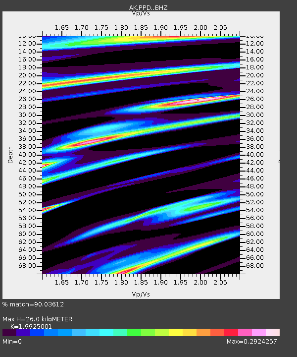
| Estimated Moho Depth: |
26.0 km |
| Estimated Crust Vp/Vs: |
1.99 |
| Assumed Crust Vp: |
6.566 km/s |
| Estimated Crust Vs: |
3.295 km/s |
| Estimated Crust Poisson's Ratio: |
0.33 |
|
| Radial Match: |
90.03612 % |
| Radial Bump: |
400 |
| Transverse Match: |
54.985996 % |
| Transverse Bump: |
400 |
| SOD ConfigId: |
13570011 |
| Insert Time: |
2019-04-30 00:52:38.050 +0000 |
| GWidth: |
2.5 |
| Max Bumps: |
400 |
| Tol: |
0.001 |
|

Signal To Noise
| Channel | StoN | STA | LTA |
| AK:PPD: :BHZ:20180329T21:37:33.187981Z | 30.836031 | 2.5772733E-6 | 8.3579934E-8 |
| AK:PPD: :BHN:20180329T21:37:33.187981Z | 4.557032 | 6.1426385E-7 | 1.3479472E-7 |
| AK:PPD: :BHE:20180329T21:37:33.187981Z | 10.349463 | 8.938486E-7 | 8.636666E-8 |
| Arrivals |
| Ps | 4.0 SECOND |
| PpPs | 12 SECOND |
| PsPs/PpSs | 16 SECOND |


