You are here: Home > Network List > AV - Alaska Volcano Observatory Stations List
> Station AU22 Augustine Mound, Augustine Volcano, Alaska > Earthquake Result Viewer
AU22 Augustine Mound, Augustine Volcano, Alaska - Earthquake Result Viewer
| Earthquake location: |
New Britain Region, P.N.G. |
| Earthquake latitude/longitude: |
-5.5/151.4 |
| Earthquake time(UTC): |
2018/03/29 (088) 21:25:32 GMT |
| Earthquake Depth: |
10 km |
| Earthquake Magnitude: |
6.9 mww |
| Earthquake Catalog/Contributor: |
NEIC PDE/us |
|
| Network: |
AV Alaska Volcano Observatory |
| Station: |
AU22 Augustine Mound, Augustine Volcano, Alaska |
| Lat/Lon: |
59.34 N/153.36 W |
| Elevation: |
105 m |
|
| Distance: |
77.9 deg |
| Az: |
25.494 deg |
| Baz: |
236.721 deg |
| Ray Param: |
0.050018452 |
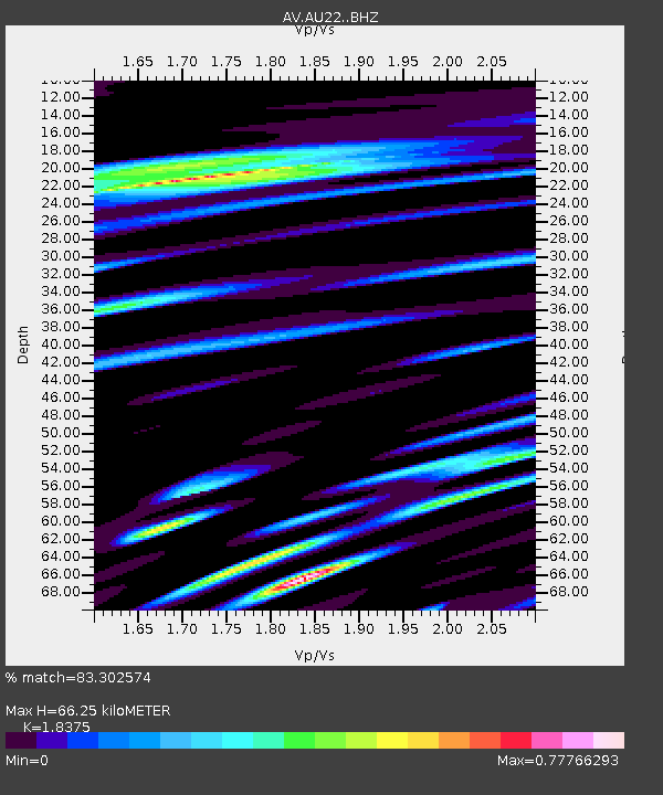
| Estimated Moho Depth: |
66.25 km |
| Estimated Crust Vp/Vs: |
1.84 |
| Assumed Crust Vp: |
5.989 km/s |
| Estimated Crust Vs: |
3.259 km/s |
| Estimated Crust Poisson's Ratio: |
0.29 |
|
| Radial Match: |
83.302574 % |
| Radial Bump: |
400 |
| Transverse Match: |
78.854095 % |
| Transverse Bump: |
400 |
| SOD ConfigId: |
13570011 |
| Insert Time: |
2019-04-30 00:53:25.921 +0000 |
| GWidth: |
2.5 |
| Max Bumps: |
400 |
| Tol: |
0.001 |
|

Signal To Noise
| Channel | StoN | STA | LTA |
| AV:AU22: :BHZ:20180329T21:37:00.078972Z | 7.8609614 | 5.4341785E-6 | 6.9128674E-7 |
| AV:AU22: :BHN:20180329T21:37:00.078972Z | 1.562789 | 1.5826415E-6 | 1.0127034E-6 |
| AV:AU22: :BHE:20180329T21:37:00.078972Z | 1.2657129 | 1.2397115E-6 | 9.794571E-7 |
| Arrivals |
| Ps | 9.5 SECOND |
| PpPs | 31 SECOND |
| PsPs/PpSs | 40 SECOND |


