You are here: Home > Network List > AV - Alaska Volcano Observatory Stations List
> Station ISLZ Lazaref River, Shishaldin Volcano, Alaska > Earthquake Result Viewer
ISLZ Lazaref River, Shishaldin Volcano, Alaska - Earthquake Result Viewer
| Earthquake location: |
New Britain Region, P.N.G. |
| Earthquake latitude/longitude: |
-5.5/151.4 |
| Earthquake time(UTC): |
2018/03/29 (088) 21:25:32 GMT |
| Earthquake Depth: |
10 km |
| Earthquake Magnitude: |
6.9 mww |
| Earthquake Catalog/Contributor: |
NEIC PDE/us |
|
| Network: |
AV Alaska Volcano Observatory |
| Station: |
ISLZ Lazaref River, Shishaldin Volcano, Alaska |
| Lat/Lon: |
54.72 N/163.71 W |
| Elevation: |
634 m |
|
| Distance: |
70.6 deg |
| Az: |
25.7 deg |
| Baz: |
228.092 deg |
| Ray Param: |
0.054881893 |
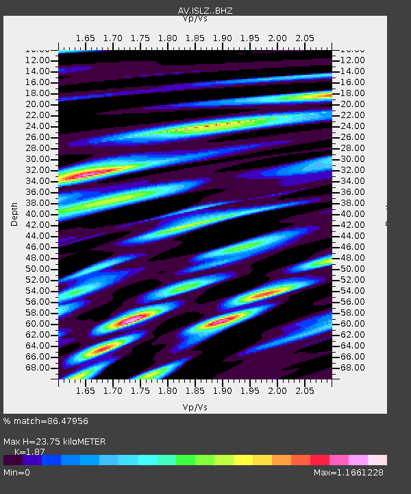
| Estimated Moho Depth: |
23.75 km |
| Estimated Crust Vp/Vs: |
1.87 |
| Assumed Crust Vp: |
5.989 km/s |
| Estimated Crust Vs: |
3.203 km/s |
| Estimated Crust Poisson's Ratio: |
0.30 |
|
| Radial Match: |
86.47956 % |
| Radial Bump: |
400 |
| Transverse Match: |
80.78188 % |
| Transverse Bump: |
400 |
| SOD ConfigId: |
13570011 |
| Insert Time: |
2019-04-30 00:53:31.451 +0000 |
| GWidth: |
2.5 |
| Max Bumps: |
400 |
| Tol: |
0.001 |
|

Signal To Noise
| Channel | StoN | STA | LTA |
| AV:ISLZ: :BHZ:20180329T21:36:17.600029Z | 17.028008 | 2.7240412E-6 | 1.5997416E-7 |
| AV:ISLZ: :BHN:20180329T21:36:17.600029Z | 2.7863648 | 9.562293E-7 | 3.4318168E-7 |
| AV:ISLZ: :BHE:20180329T21:36:17.600029Z | 4.0021443 | 1.5588982E-6 | 3.8951572E-7 |
| Arrivals |
| Ps | 3.6 SECOND |
| PpPs | 11 SECOND |
| PsPs/PpSs | 15 SECOND |


