You are here: Home > Network List > CI - Caltech Regional Seismic Network Stations List
> Station JCS Julian Camp Stevens, California, USA > Earthquake Result Viewer
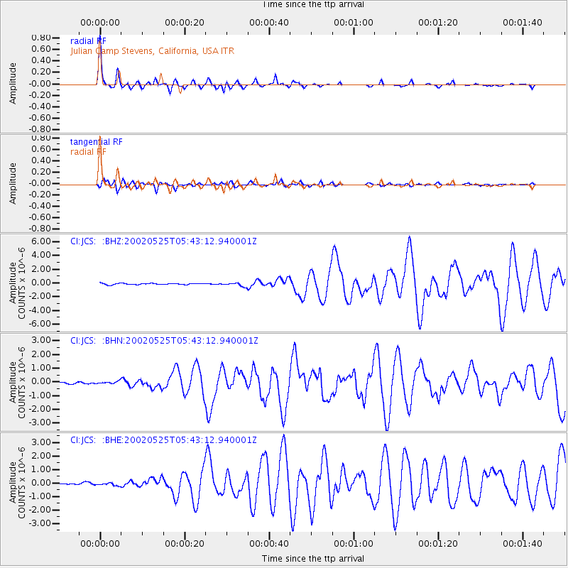
JCS Julian Camp Stevens, California, USA - Earthquake Result Viewer

| Earthquake location: |
South Of Alaska |
| Earthquake latitude/longitude: |
53.8/-161.1 |
| Earthquake time(UTC): |
2002/05/25 (145) 05:36:31 GMT |
| Earthquake Depth: |
33 km |
| Earthquake Magnitude: |
5.5 MB, 6.1 MS, 6.5 MW, 6.4 MW |
| Earthquake Catalog/Contributor: |
WHDF/NEIC |
|
| Network: |
CI Caltech Regional Seismic Network |
| Station: |
JCS Julian Camp Stevens, California, USA |
| Lat/Lon: |
33.09 N/116.60 W |
| Elevation: |
1258 m |
|
| Distance: |
37.6 deg |
| Az: |
105.189 deg |
| Baz: |
317.027 deg |
| Ray Param: |
0.07599103 |
| Estimated Moho Depth: |
28.75 km |
| Estimated Crust Vp/Vs: |
1.87 |
| Assumed Crust Vp: |
6.264 km/s |
| Estimated Crust Vs: |
3.359 km/s |
| Estimated Crust Poisson's Ratio: |
0.30 |
|
| Radial Match: |
97.03225 % |
| Radial Bump: |
303 |
| Transverse Match: |
93.11064 % |
| Transverse Bump: |
400 |
| SOD ConfigId: |
3787 |
| Insert Time: |
2010-02-26 01:53:18.440 +0000 |
| GWidth: |
2.5 |
| Max Bumps: |
400 |
| Tol: |
0.001 |
|
Signal To Noise
| Channel | StoN | STA | LTA |
| CI:JCS: :BHN:20020525T05:43:12.940001Z | 1.7688018 | 9.9423886E-8 | 5.6209736E-8 |
| CI:JCS: :BHE:20020525T05:43:12.940001Z | 1.3718442 | 1.0724663E-7 | 7.8176974E-8 |
| CI:JCS: :BHZ:20020525T05:43:12.940001Z | 2.7477863 | 2.7260867E-7 | 9.921029E-8 |
| Arrivals |
| Ps | 4.2 SECOND |
| PpPs | 12 SECOND |
| PsPs/PpSs | 17 SECOND |


