You are here: Home > Network List > AV - Alaska Volcano Observatory Stations List
> Station MNAT Nateekin Bay, Makushin Volcano, Alaska > Earthquake Result Viewer
MNAT Nateekin Bay, Makushin Volcano, Alaska - Earthquake Result Viewer
| Earthquake location: |
New Britain Region, P.N.G. |
| Earthquake latitude/longitude: |
-5.5/151.4 |
| Earthquake time(UTC): |
2018/03/29 (088) 21:25:32 GMT |
| Earthquake Depth: |
10 km |
| Earthquake Magnitude: |
6.9 mww |
| Earthquake Catalog/Contributor: |
NEIC PDE/us |
|
| Network: |
AV Alaska Volcano Observatory |
| Station: |
MNAT Nateekin Bay, Makushin Volcano, Alaska |
| Lat/Lon: |
53.88 N/166.69 W |
| Elevation: |
390 m |
|
| Distance: |
68.7 deg |
| Az: |
25.084 deg |
| Baz: |
225.469 deg |
| Ray Param: |
0.05610411 |
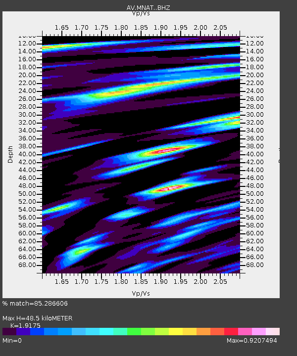
| Estimated Moho Depth: |
48.5 km |
| Estimated Crust Vp/Vs: |
1.92 |
| Assumed Crust Vp: |
3.943 km/s |
| Estimated Crust Vs: |
2.057 km/s |
| Estimated Crust Poisson's Ratio: |
0.31 |
|
| Radial Match: |
85.286606 % |
| Radial Bump: |
400 |
| Transverse Match: |
71.75907 % |
| Transverse Bump: |
400 |
| SOD ConfigId: |
13570011 |
| Insert Time: |
2019-04-30 00:53:36.983 +0000 |
| GWidth: |
2.5 |
| Max Bumps: |
400 |
| Tol: |
0.001 |
|
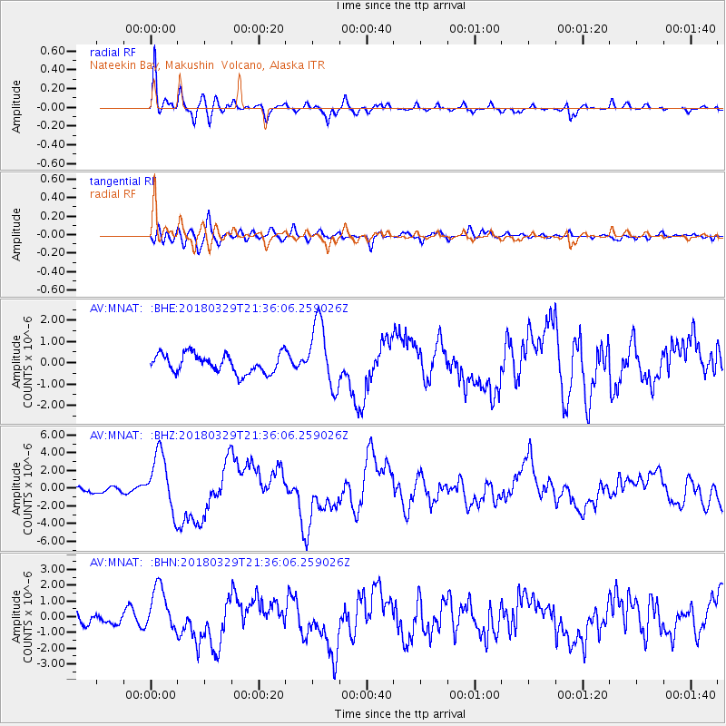
Signal To Noise
| Channel | StoN | STA | LTA |
| AV:MNAT: :BHZ:20180329T21:36:06.259026Z | 11.223154 | 3.2750359E-6 | 2.9181066E-7 |
| AV:MNAT: :BHN:20180329T21:36:06.259026Z | 4.386769 | 1.4413974E-6 | 3.2857838E-7 |
| AV:MNAT: :BHE:20180329T21:36:06.259026Z | 3.5075111 | 1.4759544E-6 | 4.207982E-7 |
| Arrivals |
| Ps | 11 SECOND |
| PpPs | 35 SECOND |
| PsPs/PpSs | 47 SECOND |


