You are here: Home > Network List > TA - USArray Transportable Network (new EarthScope stations) Stations List
> Station Y25A Mesa, Roswell, NM, USA > Earthquake Result Viewer
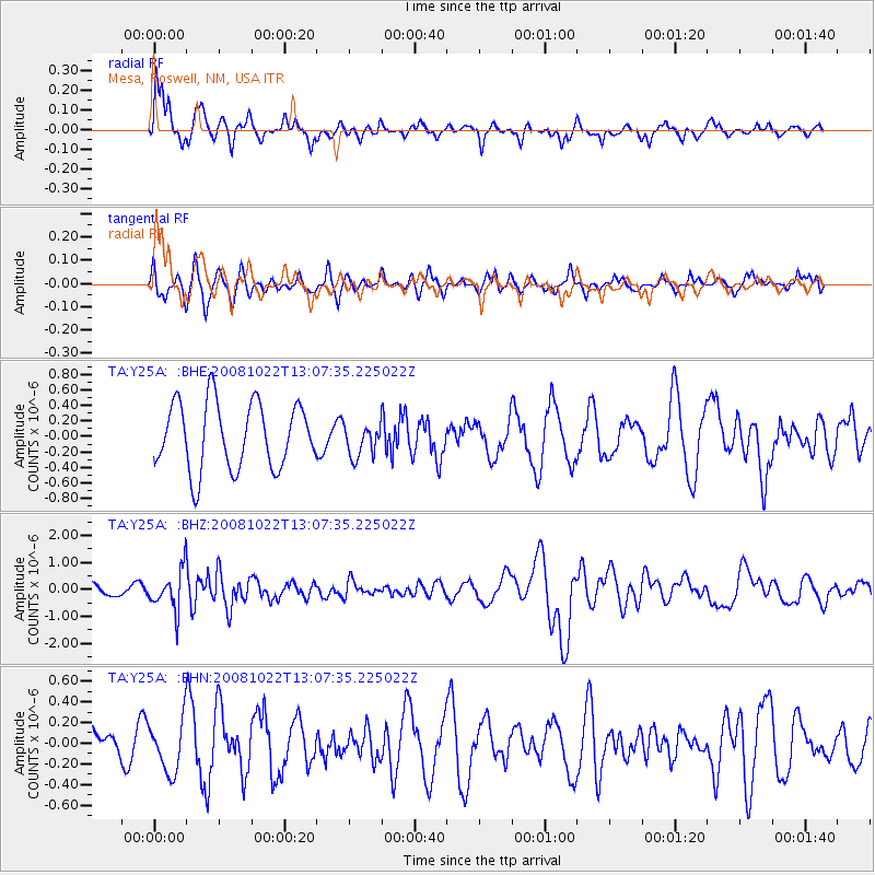
Y25A Mesa, Roswell, NM, USA - Earthquake Result Viewer
*The percent match for this event was below the threshold and hence no stack was calculated.
| Earthquake location: |
Tonga Islands |
| Earthquake latitude/longitude: |
-18.4/-175.4 |
| Earthquake time(UTC): |
2008/10/22 (296) 12:55:57 GMT |
| Earthquake Depth: |
233 km |
| Earthquake Magnitude: |
5.9 MB, 6.4 MW, 6.3 MW |
| Earthquake Catalog/Contributor: |
WHDF/NEIC |
|
| Network: |
TA USArray Transportable Network (new EarthScope stations) |
| Station: |
Y25A Mesa, Roswell, NM, USA |
| Lat/Lon: |
33.92 N/104.69 W |
| Elevation: |
1364 m |
|
| Distance: |
85.0 deg |
| Az: |
51.96 deg |
| Baz: |
244.061 deg |
| Ray Param: |
$rayparam |
*The percent match for this event was below the threshold and hence was not used in the summary stack. |
|
| Radial Match: |
78.810135 % |
| Radial Bump: |
396 |
| Transverse Match: |
42.21441 % |
| Transverse Bump: |
340 |
| SOD ConfigId: |
2560 |
| Insert Time: |
2010-03-06 10:08:46.492 +0000 |
| GWidth: |
2.5 |
| Max Bumps: |
400 |
| Tol: |
0.001 |
|
Signal To Noise
| Channel | StoN | STA | LTA |
| TA:Y25A: :BHZ:20081022T13:07:35.225022Z | 1.3780949 | 7.6008854E-7 | 5.515502E-7 |
| TA:Y25A: :BHN:20081022T13:07:35.225022Z | 0.73176503 | 2.4801244E-7 | 3.3892363E-7 |
| TA:Y25A: :BHE:20081022T13:07:35.225022Z | 0.49165133 | 2.0877812E-7 | 4.2464671E-7 |
| Arrivals |
| Ps | |
| PpPs | |
| PsPs/PpSs | |


