You are here: Home > Network List > AV - Alaska Volcano Observatory Stations List
> Station STLK Strandline Lake, Regional Station, Alaska > Earthquake Result Viewer
STLK Strandline Lake, Regional Station, Alaska - Earthquake Result Viewer
| Earthquake location: |
New Britain Region, P.N.G. |
| Earthquake latitude/longitude: |
-5.5/151.4 |
| Earthquake time(UTC): |
2018/03/29 (088) 21:25:32 GMT |
| Earthquake Depth: |
10 km |
| Earthquake Magnitude: |
6.9 mww |
| Earthquake Catalog/Contributor: |
NEIC PDE/us |
|
| Network: |
AV Alaska Volcano Observatory |
| Station: |
STLK Strandline Lake, Regional Station, Alaska |
| Lat/Lon: |
61.50 N/151.83 W |
| Elevation: |
945 m |
|
| Distance: |
79.7 deg |
| Az: |
24.051 deg |
| Baz: |
237.763 deg |
| Ray Param: |
0.048785802 |
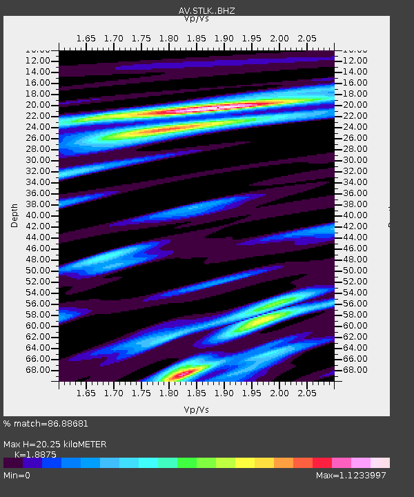
| Estimated Moho Depth: |
20.25 km |
| Estimated Crust Vp/Vs: |
1.89 |
| Assumed Crust Vp: |
6.302 km/s |
| Estimated Crust Vs: |
3.339 km/s |
| Estimated Crust Poisson's Ratio: |
0.30 |
|
| Radial Match: |
86.88681 % |
| Radial Bump: |
400 |
| Transverse Match: |
78.8922 % |
| Transverse Bump: |
400 |
| SOD ConfigId: |
13570011 |
| Insert Time: |
2019-04-30 00:53:53.800 +0000 |
| GWidth: |
2.5 |
| Max Bumps: |
400 |
| Tol: |
0.001 |
|
Signal To Noise
| Channel | StoN | STA | LTA |
| AV:STLK: :BHZ:20180329T21:37:09.879998Z | 29.493834 | 2.4146593E-6 | 8.186998E-8 |
| AV:STLK: :BHN:20180329T21:37:09.879998Z | 6.5057034 | 5.091285E-7 | 7.825879E-8 |
| AV:STLK: :BHE:20180329T21:37:09.879998Z | 12.239164 | 6.37134E-7 | 5.2056986E-8 |
| Arrivals |
| Ps | 2.9 SECOND |
| PpPs | 9.0 SECOND |
| PsPs/PpSs | 12 SECOND |


