You are here: Home > Network List > AV - Alaska Volcano Observatory Stations List
> Station WEBT Beartrack Creek, Westdahl Peak, Alaska > Earthquake Result Viewer
WEBT Beartrack Creek, Westdahl Peak, Alaska - Earthquake Result Viewer

| Earthquake location: |
New Britain Region, P.N.G. |
| Earthquake latitude/longitude: |
-5.5/151.4 |
| Earthquake time(UTC): |
2018/03/29 (088) 21:25:32 GMT |
| Earthquake Depth: |
10 km |
| Earthquake Magnitude: |
6.9 mww |
| Earthquake Catalog/Contributor: |
NEIC PDE/us |
|
| Network: |
AV Alaska Volcano Observatory |
| Station: |
WEBT Beartrack Creek, Westdahl Peak, Alaska |
| Lat/Lon: |
54.59 N/164.76 W |
| Elevation: |
467 m |
|
| Distance: |
70.1 deg |
| Az: |
25.373 deg |
| Baz: |
227.134 deg |
| Ray Param: |
0.0552388 |
| Estimated Moho Depth: |
28.25 km |
| Estimated Crust Vp/Vs: |
1.67 |
| Assumed Crust Vp: |
5.989 km/s |
| Estimated Crust Vs: |
3.592 km/s |
| Estimated Crust Poisson's Ratio: |
0.22 |
|
| Radial Match: |
84.24479 % |
| Radial Bump: |
400 |
| Transverse Match: |
79.99621 % |
| Transverse Bump: |
400 |
| SOD ConfigId: |
13570011 |
| Insert Time: |
2019-04-30 00:53:55.941 +0000 |
| GWidth: |
2.5 |
| Max Bumps: |
400 |
| Tol: |
0.001 |
|
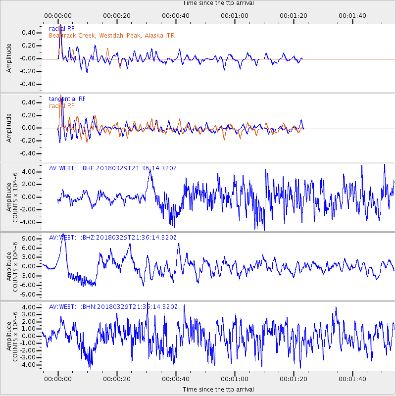
Signal To Noise
| Channel | StoN | STA | LTA |
| AV:WEBT: :BHZ:20180329T21:36:14.320Z | 13.490993 | 5.549551E-6 | 4.1135235E-7 |
| AV:WEBT: :BHN:20180329T21:36:14.320Z | 2.260672 | 1.2125046E-6 | 5.36347E-7 |
| AV:WEBT: :BHE:20180329T21:36:14.320Z | 3.1804612 | 2.0572288E-6 | 6.468335E-7 |
| Arrivals |
| Ps | 3.3 SECOND |
| PpPs | 12 SECOND |
| PsPs/PpSs | 15 SECOND |


