You are here: Home > Network List > CC - Cascade Chain Volcano Monitoring Stations List
> Station CLBH Crater Lake, OR, USA > Earthquake Result Viewer
CLBH Crater Lake, OR, USA - Earthquake Result Viewer
| Earthquake location: |
New Britain Region, P.N.G. |
| Earthquake latitude/longitude: |
-5.5/151.4 |
| Earthquake time(UTC): |
2018/03/29 (088) 21:25:32 GMT |
| Earthquake Depth: |
10 km |
| Earthquake Magnitude: |
6.9 mww |
| Earthquake Catalog/Contributor: |
NEIC PDE/us |
|
| Network: |
CC Cascade Chain Volcano Monitoring |
| Station: |
CLBH Crater Lake, OR, USA |
| Lat/Lon: |
42.91 N/122.14 W |
| Elevation: |
2197 m |
|
| Distance: |
91.1 deg |
| Az: |
47.173 deg |
| Baz: |
263.572 deg |
| Ray Param: |
0.04162927 |
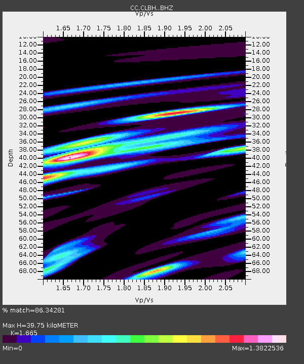
| Estimated Moho Depth: |
39.75 km |
| Estimated Crust Vp/Vs: |
1.66 |
| Assumed Crust Vp: |
6.522 km/s |
| Estimated Crust Vs: |
3.917 km/s |
| Estimated Crust Poisson's Ratio: |
0.22 |
|
| Radial Match: |
86.34281 % |
| Radial Bump: |
400 |
| Transverse Match: |
68.70733 % |
| Transverse Bump: |
400 |
| SOD ConfigId: |
13570011 |
| Insert Time: |
2019-04-30 00:54:26.306 +0000 |
| GWidth: |
2.5 |
| Max Bumps: |
400 |
| Tol: |
0.001 |
|

Signal To Noise
| Channel | StoN | STA | LTA |
| CC:CLBH: :BHZ:20180329T21:38:06.260002Z | 14.868253 | 3.0207211E-6 | 2.0316585E-7 |
| CC:CLBH: :BHN:20180329T21:38:06.260002Z | 2.22492 | 7.145626E-7 | 3.2116324E-7 |
| CC:CLBH: :BHE:20180329T21:38:06.260002Z | 3.4862006 | 1.2464994E-6 | 3.5755244E-7 |
| Arrivals |
| Ps | 4.1 SECOND |
| PpPs | 16 SECOND |
| PsPs/PpSs | 20 SECOND |


