You are here: Home > Network List > CC - Cascade Chain Volcano Monitoring Stations List
> Station STD Studebaker Ridge, Mount St Helens, WA > Earthquake Result Viewer
STD Studebaker Ridge, Mount St Helens, WA - Earthquake Result Viewer
| Earthquake location: |
New Britain Region, P.N.G. |
| Earthquake latitude/longitude: |
-5.5/151.4 |
| Earthquake time(UTC): |
2018/03/29 (088) 21:25:32 GMT |
| Earthquake Depth: |
10 km |
| Earthquake Magnitude: |
6.9 mww |
| Earthquake Catalog/Contributor: |
NEIC PDE/us |
|
| Network: |
CC Cascade Chain Volcano Monitoring |
| Station: |
STD Studebaker Ridge, Mount St Helens, WA |
| Lat/Lon: |
46.24 N/122.22 W |
| Elevation: |
1268 m |
|
| Distance: |
91.4 deg |
| Az: |
43.857 deg |
| Baz: |
263.586 deg |
| Ray Param: |
0.041606784 |
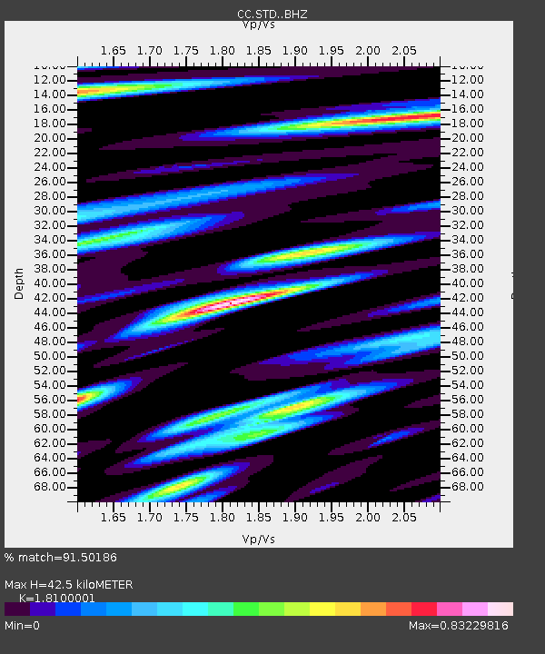
| Estimated Moho Depth: |
42.5 km |
| Estimated Crust Vp/Vs: |
1.81 |
| Assumed Crust Vp: |
6.566 km/s |
| Estimated Crust Vs: |
3.628 km/s |
| Estimated Crust Poisson's Ratio: |
0.28 |
|
| Radial Match: |
91.50186 % |
| Radial Bump: |
400 |
| Transverse Match: |
81.12601 % |
| Transverse Bump: |
400 |
| SOD ConfigId: |
13570011 |
| Insert Time: |
2019-04-30 00:54:36.049 +0000 |
| GWidth: |
2.5 |
| Max Bumps: |
400 |
| Tol: |
0.001 |
|

Signal To Noise
| Channel | StoN | STA | LTA |
| CC:STD: :BHZ:20180329T21:38:07.725029Z | 40.70998 | 3.1168909E-6 | 7.656332E-8 |
| CC:STD: :BHN:20180329T21:38:07.725029Z | 0.8809211 | 1.3647637E-7 | 1.5492463E-7 |
| CC:STD: :BHE:20180329T21:38:07.725029Z | 8.234772 | 9.957175E-7 | 1.2091623E-7 |
| Arrivals |
| Ps | 5.4 SECOND |
| PpPs | 18 SECOND |
| PsPs/PpSs | 23 SECOND |


