You are here: Home > Network List > CI - Caltech Regional Seismic Network Stations List
> Station SWS Sam W. Stewart, Westmorland, CA, USA > Earthquake Result Viewer
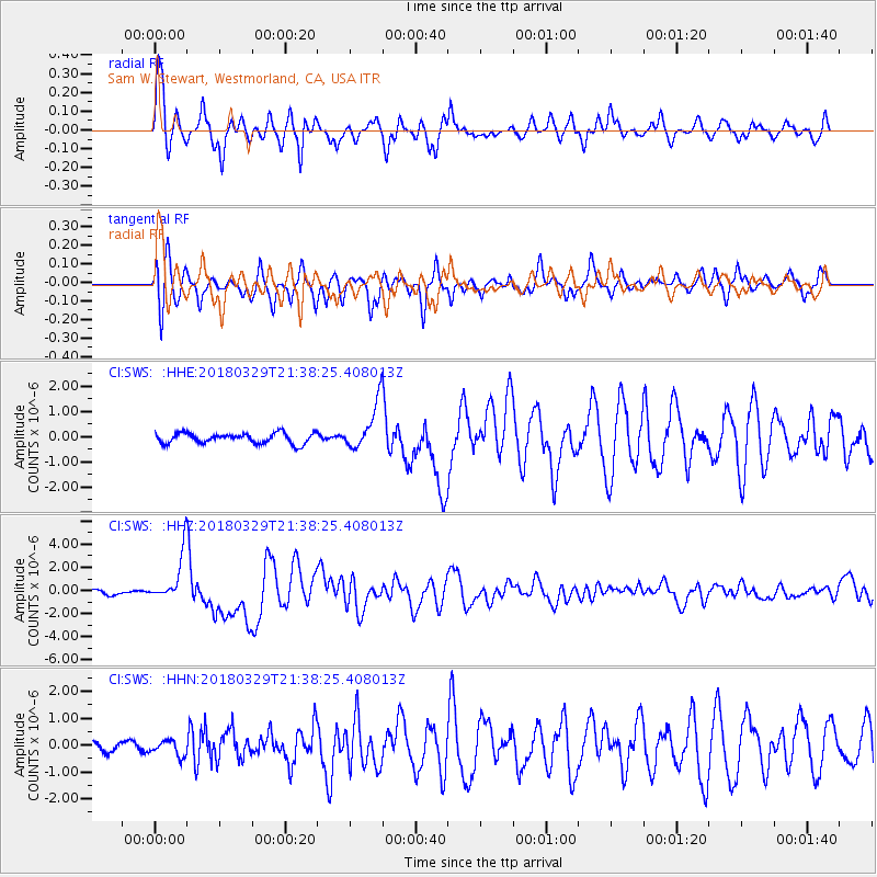
SWS Sam W. Stewart, Westmorland, CA, USA - Earthquake Result Viewer

| Earthquake location: |
New Britain Region, P.N.G. |
| Earthquake latitude/longitude: |
-5.5/151.4 |
| Earthquake time(UTC): |
2018/03/29 (088) 21:25:32 GMT |
| Earthquake Depth: |
10 km |
| Earthquake Magnitude: |
6.9 mww |
| Earthquake Catalog/Contributor: |
NEIC PDE/us |
|
| Network: |
CI Caltech Regional Seismic Network |
| Station: |
SWS Sam W. Stewart, Westmorland, CA, USA |
| Lat/Lon: |
32.94 N/115.80 W |
| Elevation: |
140 m |
|
| Distance: |
95.3 deg |
| Az: |
57.507 deg |
| Baz: |
266.904 deg |
| Ray Param: |
0.04083215 |
| Estimated Moho Depth: |
42.75 km |
| Estimated Crust Vp/Vs: |
1.99 |
| Assumed Crust Vp: |
6.155 km/s |
| Estimated Crust Vs: |
3.089 km/s |
| Estimated Crust Poisson's Ratio: |
0.33 |
|
| Radial Match: |
93.30087 % |
| Radial Bump: |
400 |
| Transverse Match: |
81.26467 % |
| Transverse Bump: |
400 |
| SOD ConfigId: |
13570011 |
| Insert Time: |
2019-04-30 00:55:26.097 +0000 |
| GWidth: |
2.5 |
| Max Bumps: |
400 |
| Tol: |
0.001 |
|
Signal To Noise
| Channel | StoN | STA | LTA |
| CI:SWS: :HHZ:20180329T21:38:25.408013Z | 14.06741 | 2.133906E-6 | 1.5169145E-7 |
| CI:SWS: :HHN:20180329T21:38:25.408013Z | 1.4150671 | 2.7930292E-7 | 1.9737787E-7 |
| CI:SWS: :HHE:20180329T21:38:25.408013Z | 3.4277172 | 7.06691E-7 | 2.0616957E-7 |
| Arrivals |
| Ps | 7.0 SECOND |
| PpPs | 20 SECOND |
| PsPs/PpSs | 27 SECOND |


