You are here: Home > Network List > NM - Cooperative New Madrid Seismic Network Stations List
> Station SLM St. Louis, MO > Earthquake Result Viewer
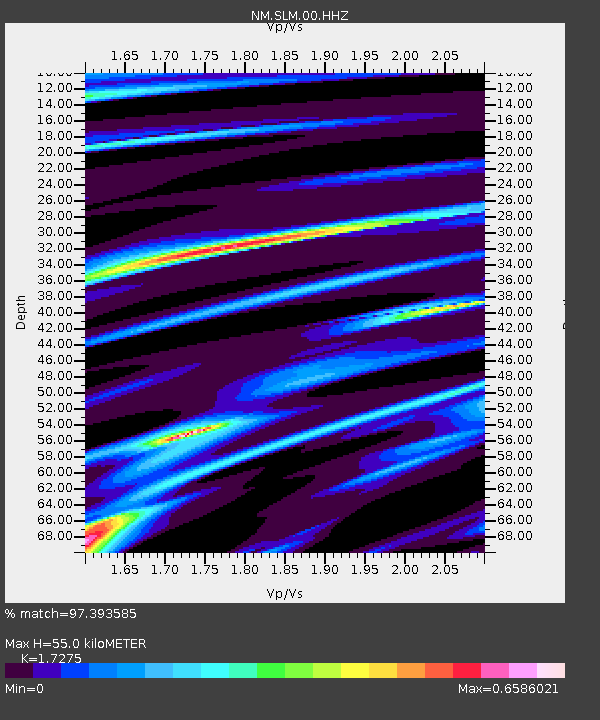
SLM St. Louis, MO - Earthquake Result Viewer
| Earthquake location: |
Northern East Pacific Rise |
| Earthquake latitude/longitude: |
10.3/-103.8 |
| Earthquake time(UTC): |
2016/04/29 (120) 01:33:38 GMT |
| Earthquake Depth: |
10 km |
| Earthquake Magnitude: |
6.8 MWP, 6.9 MI |
| Earthquake Catalog/Contributor: |
NEIC PDE/NEIC COMCAT |
|
| Network: |
NM Cooperative New Madrid Seismic Network |
| Station: |
SLM St. Louis, MO |
| Lat/Lon: |
38.64 N/90.24 W |
| Elevation: |
186 m |
|
| Distance: |
30.8 deg |
| Az: |
20.991 deg |
| Baz: |
206.756 deg |
| Ray Param: |
0.07924972 |
| Estimated Moho Depth: |
55.0 km |
| Estimated Crust Vp/Vs: |
1.73 |
| Assumed Crust Vp: |
6.498 km/s |
| Estimated Crust Vs: |
3.761 km/s |
| Estimated Crust Poisson's Ratio: |
0.25 |
|
| Radial Match: |
97.393585 % |
| Radial Bump: |
215 |
| Transverse Match: |
77.40674 % |
| Transverse Bump: |
400 |
| SOD ConfigId: |
1475611 |
| Insert Time: |
2016-05-13 01:39:56.467 +0000 |
| GWidth: |
2.5 |
| Max Bumps: |
400 |
| Tol: |
0.001 |
|

Signal To Noise
| Channel | StoN | STA | LTA |
| NM:SLM:00:HHZ:20160429T01:39:23.480004Z | 15.681549 | 2.2943518E-6 | 1.46309E-7 |
| NM:SLM:00:HHN:20160429T01:39:23.480004Z | 10.788008 | 1.3912967E-6 | 1.2896697E-7 |
| NM:SLM:00:HHE:20160429T01:39:23.480004Z | 5.1705213 | 6.8530414E-7 | 1.3254063E-7 |
| Arrivals |
| Ps | 6.7 SECOND |
| PpPs | 21 SECOND |
| PsPs/PpSs | 28 SECOND |


