You are here: Home > Network List > TA - USArray Transportable Network (new EarthScope stations) Stations List
> Station Y25A Mesa, Roswell, NM, USA > Earthquake Result Viewer
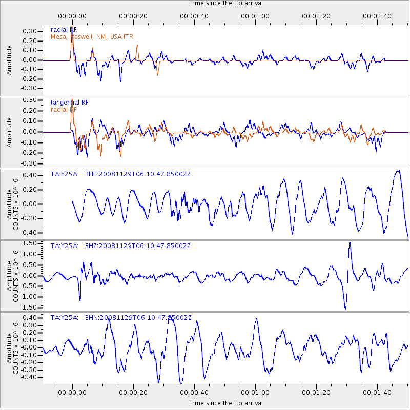
Y25A Mesa, Roswell, NM, USA - Earthquake Result Viewer
*The percent match for this event was below the threshold and hence no stack was calculated.
| Earthquake location: |
Fiji Islands Region |
| Earthquake latitude/longitude: |
-18.7/-177.7 |
| Earthquake time(UTC): |
2008/11/29 (334) 05:59:16 GMT |
| Earthquake Depth: |
386 km |
| Earthquake Magnitude: |
5.7 MB, 6.0 MW, 5.9 MW |
| Earthquake Catalog/Contributor: |
WHDF/NEIC |
|
| Network: |
TA USArray Transportable Network (new EarthScope stations) |
| Station: |
Y25A Mesa, Roswell, NM, USA |
| Lat/Lon: |
33.92 N/104.69 W |
| Elevation: |
1364 m |
|
| Distance: |
87.0 deg |
| Az: |
52.788 deg |
| Baz: |
245.207 deg |
| Ray Param: |
$rayparam |
*The percent match for this event was below the threshold and hence was not used in the summary stack. |
|
| Radial Match: |
50.32867 % |
| Radial Bump: |
242 |
| Transverse Match: |
54.323193 % |
| Transverse Bump: |
280 |
| SOD ConfigId: |
2658 |
| Insert Time: |
2010-03-06 10:09:20.406 +0000 |
| GWidth: |
2.5 |
| Max Bumps: |
400 |
| Tol: |
0.001 |
|
Signal To Noise
| Channel | StoN | STA | LTA |
| TA:Y25A: :BHZ:20081129T06:10:47.85002Z | 2.3739188 | 3.7389216E-7 | 1.5749998E-7 |
| TA:Y25A: :BHN:20081129T06:10:47.85002Z | 0.43228072 | 5.5072597E-8 | 1.2740007E-7 |
| TA:Y25A: :BHE:20081129T06:10:47.85002Z | 0.95341474 | 1.2722066E-7 | 1.3343686E-7 |
| Arrivals |
| Ps | |
| PpPs | |
| PsPs/PpSs | |


