You are here: Home > Network List > TA - USArray Transportable Network (new EarthScope stations) Stations List
> Station Y25A Mesa, Roswell, NM, USA > Earthquake Result Viewer
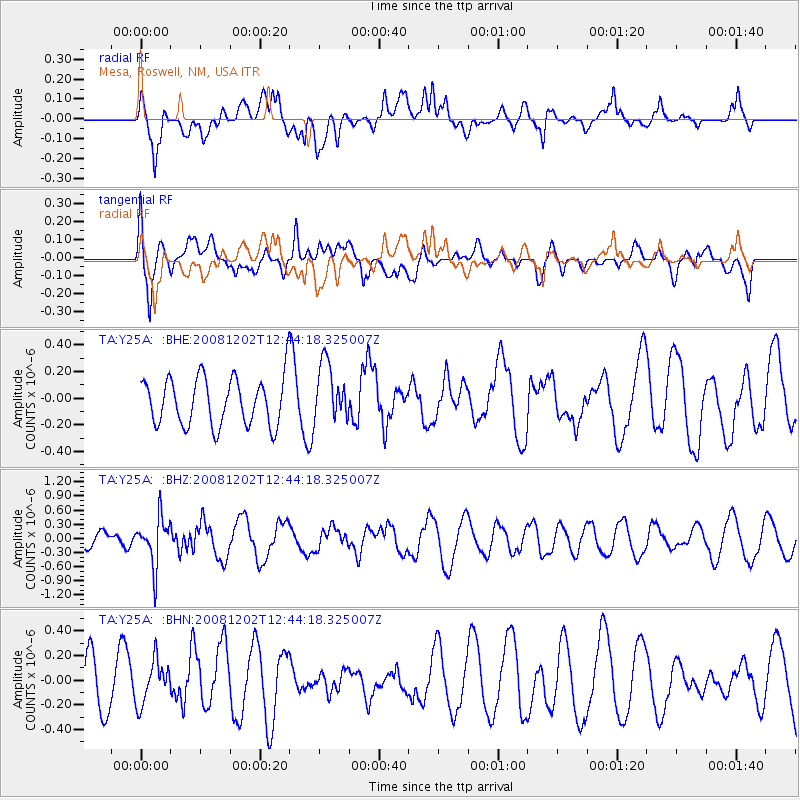
Y25A Mesa, Roswell, NM, USA - Earthquake Result Viewer
*The percent match for this event was below the threshold and hence no stack was calculated.
| Earthquake location: |
Mariana Islands |
| Earthquake latitude/longitude: |
19.1/145.8 |
| Earthquake time(UTC): |
2008/12/02 (337) 12:31:43 GMT |
| Earthquake Depth: |
137 km |
| Earthquake Magnitude: |
5.9 MB, 5.9 MW, 5.9 MW |
| Earthquake Catalog/Contributor: |
WHDF/NEIC |
|
| Network: |
TA USArray Transportable Network (new EarthScope stations) |
| Station: |
Y25A Mesa, Roswell, NM, USA |
| Lat/Lon: |
33.92 N/104.69 W |
| Elevation: |
1364 m |
|
| Distance: |
94.7 deg |
| Az: |
51.834 deg |
| Baz: |
296.611 deg |
| Ray Param: |
$rayparam |
*The percent match for this event was below the threshold and hence was not used in the summary stack. |
|
| Radial Match: |
61.167053 % |
| Radial Bump: |
400 |
| Transverse Match: |
50.80472 % |
| Transverse Bump: |
400 |
| SOD ConfigId: |
2658 |
| Insert Time: |
2010-03-06 10:09:26.306 +0000 |
| GWidth: |
2.5 |
| Max Bumps: |
400 |
| Tol: |
0.001 |
|
Signal To Noise
| Channel | StoN | STA | LTA |
| TA:Y25A: :BHZ:20081202T12:44:18.325007Z | 1.8019953 | 5.097851E-7 | 2.8290034E-7 |
| TA:Y25A: :BHN:20081202T12:44:18.325007Z | 0.77359796 | 1.7439247E-7 | 2.2543036E-7 |
| TA:Y25A: :BHE:20081202T12:44:18.325007Z | 1.2124082 | 2.1883395E-7 | 1.8049528E-7 |
| Arrivals |
| Ps | |
| PpPs | |
| PsPs/PpSs | |


