You are here: Home > Network List > NN - Western Great Basin/Eastern Sierra Nevada Stations List
> Station QSM Queen of Sheba Mine, CA. (GPS 01/17/2001) w84gm > Earthquake Result Viewer
QSM Queen of Sheba Mine, CA. (GPS 01/17/2001) w84gm - Earthquake Result Viewer
| Earthquake location: |
New Britain Region, P.N.G. |
| Earthquake latitude/longitude: |
-5.5/151.4 |
| Earthquake time(UTC): |
2018/03/29 (088) 21:25:32 GMT |
| Earthquake Depth: |
10 km |
| Earthquake Magnitude: |
6.9 mww |
| Earthquake Catalog/Contributor: |
NEIC PDE/us |
|
| Network: |
NN Western Great Basin/Eastern Sierra Nevada |
| Station: |
QSM Queen of Sheba Mine, CA. (GPS 01/17/2001) w84gm |
| Lat/Lon: |
35.97 N/116.87 W |
| Elevation: |
385 m |
|
| Distance: |
94.5 deg |
| Az: |
54.434 deg |
| Baz: |
266.562 deg |
| Ray Param: |
0.041020412 |
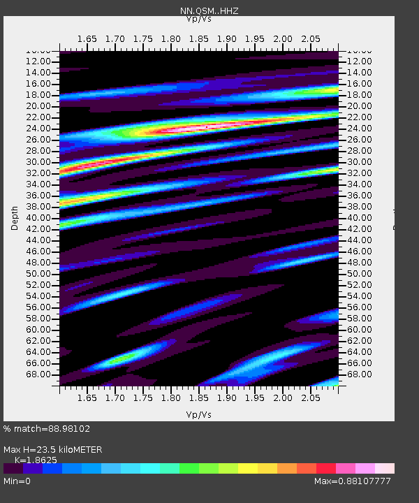
| Estimated Moho Depth: |
23.5 km |
| Estimated Crust Vp/Vs: |
1.86 |
| Assumed Crust Vp: |
6.276 km/s |
| Estimated Crust Vs: |
3.37 km/s |
| Estimated Crust Poisson's Ratio: |
0.30 |
|
| Radial Match: |
88.98102 % |
| Radial Bump: |
400 |
| Transverse Match: |
71.56221 % |
| Transverse Bump: |
400 |
| SOD ConfigId: |
13570011 |
| Insert Time: |
2019-04-30 00:57:29.205 +0000 |
| GWidth: |
2.5 |
| Max Bumps: |
400 |
| Tol: |
0.001 |
|

Signal To Noise
| Channel | StoN | STA | LTA |
| NN:QSM: :HHZ:20180329T21:38:22.197991Z | 12.349693 | 2.162132E-6 | 1.7507577E-7 |
| NN:QSM: :HHN:20180329T21:38:22.197991Z | 0.889855 | 1.480733E-7 | 1.6640159E-7 |
| NN:QSM: :HHE:20180329T21:38:22.197991Z | 3.6764474 | 5.212406E-7 | 1.4177836E-7 |
| Arrivals |
| Ps | 3.3 SECOND |
| PpPs | 11 SECOND |
| PsPs/PpSs | 14 SECOND |


