You are here: Home > Network List > PY - PFO Array Stations List
> Station BPH12 Pinon Flat Observatory, CA, USA > Earthquake Result Viewer
BPH12 Pinon Flat Observatory, CA, USA - Earthquake Result Viewer
| Earthquake location: |
New Britain Region, P.N.G. |
| Earthquake latitude/longitude: |
-5.5/151.4 |
| Earthquake time(UTC): |
2018/03/29 (088) 21:25:32 GMT |
| Earthquake Depth: |
10 km |
| Earthquake Magnitude: |
6.9 mww |
| Earthquake Catalog/Contributor: |
NEIC PDE/us |
|
| Network: |
PY PFO Array |
| Station: |
BPH12 Pinon Flat Observatory, CA, USA |
| Lat/Lon: |
33.61 N/116.46 W |
| Elevation: |
1251 m |
|
| Distance: |
94.7 deg |
| Az: |
56.811 deg |
| Baz: |
266.602 deg |
| Ray Param: |
0.040969715 |
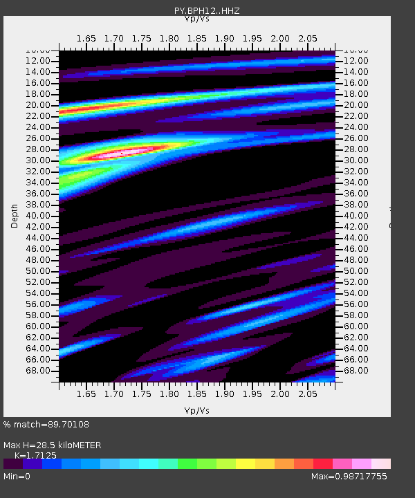
| Estimated Moho Depth: |
28.5 km |
| Estimated Crust Vp/Vs: |
1.71 |
| Assumed Crust Vp: |
6.264 km/s |
| Estimated Crust Vs: |
3.658 km/s |
| Estimated Crust Poisson's Ratio: |
0.24 |
|
| Radial Match: |
89.70108 % |
| Radial Bump: |
330 |
| Transverse Match: |
79.12989 % |
| Transverse Bump: |
400 |
| SOD ConfigId: |
13570011 |
| Insert Time: |
2019-04-30 00:58:09.138 +0000 |
| GWidth: |
2.5 |
| Max Bumps: |
400 |
| Tol: |
0.001 |
|

Signal To Noise
| Channel | StoN | STA | LTA |
| PY:BPH12: :HHZ:20180329T21:38:23.075005Z | 12.38609 | 1.972535E-6 | 1.5925406E-7 |
| PY:BPH12: :HHN:20180329T21:38:23.075005Z | 1.0165384 | 1.4874625E-7 | 1.4632626E-7 |
| PY:BPH12: :HHE:20180329T21:38:23.075005Z | 6.668674 | 5.5869816E-7 | 8.37795E-8 |
| Arrivals |
| Ps | 3.3 SECOND |
| PpPs | 12 SECOND |
| PsPs/PpSs | 15 SECOND |


