You are here: Home > Network List > RV - Regional Alberta Seismic Observatory for Earthquake Studies Network Stations List
> Station HILA High Level, AB > Earthquake Result Viewer
HILA High Level, AB - Earthquake Result Viewer
| Earthquake location: |
New Britain Region, P.N.G. |
| Earthquake latitude/longitude: |
-5.5/151.4 |
| Earthquake time(UTC): |
2018/03/29 (088) 21:25:32 GMT |
| Earthquake Depth: |
10 km |
| Earthquake Magnitude: |
6.9 mww |
| Earthquake Catalog/Contributor: |
NEIC PDE/us |
|
| Network: |
RV Regional Alberta Seismic Observatory for Earthquake Studies Network |
| Station: |
HILA High Level, AB |
| Lat/Lon: |
58.56 N/117.02 W |
| Elevation: |
329 m |
|
| Distance: |
95.4 deg |
| Az: |
31.762 deg |
| Baz: |
268.444 deg |
| Ray Param: |
0.040784594 |
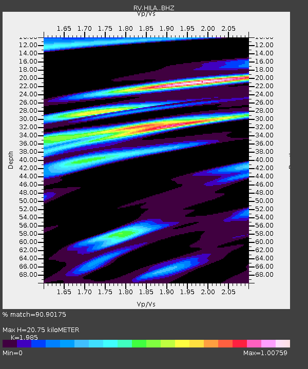
| Estimated Moho Depth: |
20.75 km |
| Estimated Crust Vp/Vs: |
1.99 |
| Assumed Crust Vp: |
6.498 km/s |
| Estimated Crust Vs: |
3.273 km/s |
| Estimated Crust Poisson's Ratio: |
0.33 |
|
| Radial Match: |
90.90175 % |
| Radial Bump: |
400 |
| Transverse Match: |
72.15875 % |
| Transverse Bump: |
400 |
| SOD ConfigId: |
13570011 |
| Insert Time: |
2019-04-30 00:58:20.416 +0000 |
| GWidth: |
2.5 |
| Max Bumps: |
400 |
| Tol: |
0.001 |
|

Signal To Noise
| Channel | StoN | STA | LTA |
| RV:HILA: :BHZ:20180329T21:38:26.350029Z | 20.076735 | 4.76436E-5 | 2.3730752E-6 |
| RV:HILA: :BHN:20180329T21:38:26.350029Z | 1.0782627 | 4.431397E-6 | 4.1097564E-6 |
| RV:HILA: :BHE:20180329T21:38:26.350029Z | 6.0265574 | 1.8198763E-5 | 3.019761E-6 |
| Arrivals |
| Ps | 3.2 SECOND |
| PpPs | 9.4 SECOND |
| PsPs/PpSs | 13 SECOND |


