You are here: Home > Network List > S - Seismographs in Schools Projects Stations List
> Station AUBRN Burnie High School, Burnie, TAS > Earthquake Result Viewer
AUBRN Burnie High School, Burnie, TAS - Earthquake Result Viewer
| Earthquake location: |
New Britain Region, P.N.G. |
| Earthquake latitude/longitude: |
-5.5/151.4 |
| Earthquake time(UTC): |
2018/03/29 (088) 21:25:32 GMT |
| Earthquake Depth: |
10 km |
| Earthquake Magnitude: |
6.9 mww |
| Earthquake Catalog/Contributor: |
NEIC PDE/us |
|
| Network: |
S Seismographs in Schools Projects |
| Station: |
AUBRN Burnie High School, Burnie, TAS |
| Lat/Lon: |
41.04 S/145.87 E |
| Elevation: |
10 m |
|
| Distance: |
35.8 deg |
| Az: |
187.231 deg |
| Baz: |
9.535 deg |
| Ray Param: |
0.07704736 |
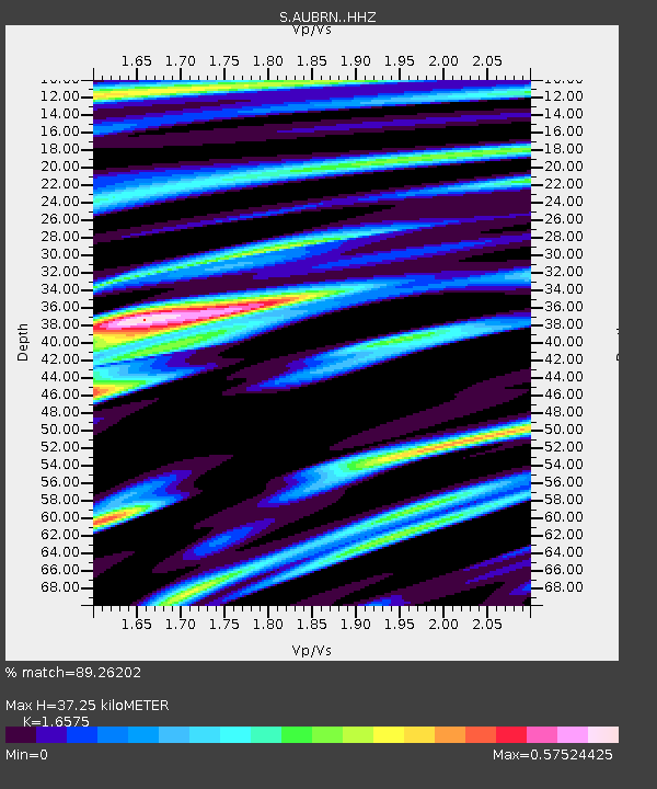
| Estimated Moho Depth: |
37.25 km |
| Estimated Crust Vp/Vs: |
1.66 |
| Assumed Crust Vp: |
6.477 km/s |
| Estimated Crust Vs: |
3.907 km/s |
| Estimated Crust Poisson's Ratio: |
0.21 |
|
| Radial Match: |
89.26202 % |
| Radial Bump: |
400 |
| Transverse Match: |
75.36749 % |
| Transverse Bump: |
400 |
| SOD ConfigId: |
13570011 |
| Insert Time: |
2019-04-30 00:58:26.214 +0000 |
| GWidth: |
2.5 |
| Max Bumps: |
400 |
| Tol: |
0.001 |
|

Signal To Noise
| Channel | StoN | STA | LTA |
| S:AUBRN: :HHZ:20180329T21:32:02.020012Z | 2.18401 | 1.8086854E-6 | 8.2814887E-7 |
| S:AUBRN: :HHN:20180329T21:32:02.020012Z | 1.3726664 | 1.0027122E-6 | 7.3048506E-7 |
| S:AUBRN: :HHE:20180329T21:32:02.020012Z | 0.99611413 | 6.559711E-7 | 6.585301E-7 |
| Arrivals |
| Ps | 4.1 SECOND |
| PpPs | 14 SECOND |
| PsPs/PpSs | 18 SECOND |


