You are here: Home > Network List > S - Seismographs in Schools Projects Stations List
> Station AUMBR Murray Bridge High School, SA > Earthquake Result Viewer
AUMBR Murray Bridge High School, SA - Earthquake Result Viewer
| Earthquake location: |
New Britain Region, P.N.G. |
| Earthquake latitude/longitude: |
-5.5/151.4 |
| Earthquake time(UTC): |
2018/03/29 (088) 21:25:32 GMT |
| Earthquake Depth: |
10 km |
| Earthquake Magnitude: |
6.9 mww |
| Earthquake Catalog/Contributor: |
NEIC PDE/us |
|
| Network: |
S Seismographs in Schools Projects |
| Station: |
AUMBR Murray Bridge High School, SA |
| Lat/Lon: |
35.13 S/139.29 E |
| Elevation: |
38 m |
|
| Distance: |
31.6 deg |
| Az: |
199.254 deg |
| Baz: |
23.611 deg |
| Ray Param: |
0.07901604 |
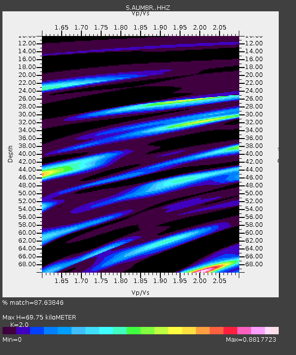
| Estimated Moho Depth: |
69.75 km |
| Estimated Crust Vp/Vs: |
2.00 |
| Assumed Crust Vp: |
6.576 km/s |
| Estimated Crust Vs: |
3.288 km/s |
| Estimated Crust Poisson's Ratio: |
0.33 |
|
| Radial Match: |
87.63846 % |
| Radial Bump: |
360 |
| Transverse Match: |
52.616913 % |
| Transverse Bump: |
400 |
| SOD ConfigId: |
13570011 |
| Insert Time: |
2019-04-30 00:58:32.172 +0000 |
| GWidth: |
2.5 |
| Max Bumps: |
400 |
| Tol: |
0.001 |
|

Signal To Noise
| Channel | StoN | STA | LTA |
| S:AUMBR: :HHZ:20180329T21:31:25.879998Z | 1.5226836 | 1.5203018E-6 | 9.984358E-7 |
| S:AUMBR: :HHN:20180329T21:31:25.879998Z | 1.4026743 | 1.1072682E-6 | 7.893979E-7 |
| S:AUMBR: :HHE:20180329T21:31:25.879998Z | 0.6406515 | 5.762056E-7 | 8.994056E-7 |
| Arrivals |
| Ps | 11 SECOND |
| PpPs | 30 SECOND |
| PsPs/PpSs | 41 SECOND |


