You are here: Home > Network List > TA - USArray Transportable Network (new EarthScope stations) Stations List
> Station B18K Kokolik River, AK, USA > Earthquake Result Viewer
B18K Kokolik River, AK, USA - Earthquake Result Viewer
| Earthquake location: |
New Britain Region, P.N.G. |
| Earthquake latitude/longitude: |
-5.5/151.4 |
| Earthquake time(UTC): |
2018/03/29 (088) 21:25:32 GMT |
| Earthquake Depth: |
10 km |
| Earthquake Magnitude: |
6.9 mww |
| Earthquake Catalog/Contributor: |
NEIC PDE/us |
|
| Network: |
TA USArray Transportable Network (new EarthScope stations) |
| Station: |
B18K Kokolik River, AK, USA |
| Lat/Lon: |
69.36 N/161.80 W |
| Elevation: |
222 m |
|
| Distance: |
81.2 deg |
| Az: |
15.147 deg |
| Baz: |
227.201 deg |
| Ray Param: |
0.047763404 |
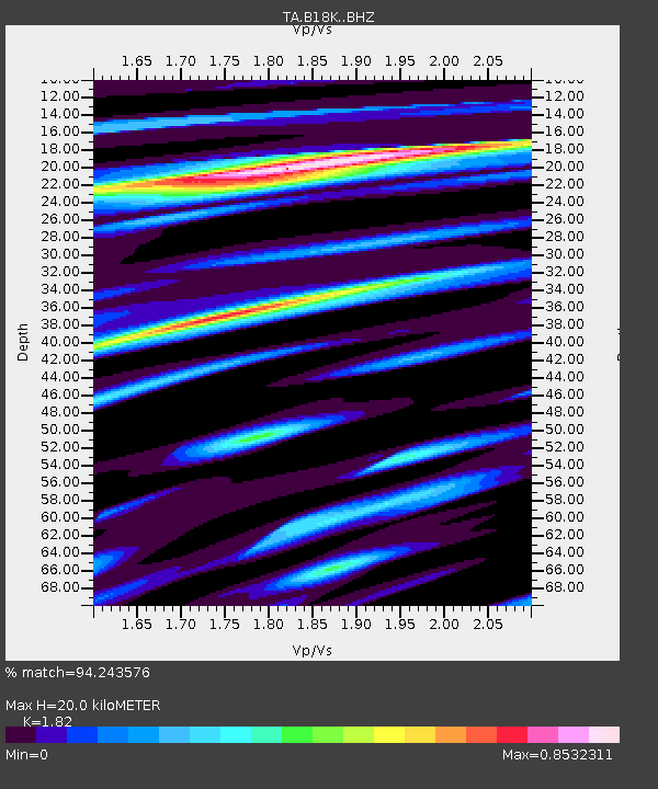
| Estimated Moho Depth: |
20.0 km |
| Estimated Crust Vp/Vs: |
1.82 |
| Assumed Crust Vp: |
5.906 km/s |
| Estimated Crust Vs: |
3.245 km/s |
| Estimated Crust Poisson's Ratio: |
0.28 |
|
| Radial Match: |
94.243576 % |
| Radial Bump: |
400 |
| Transverse Match: |
80.00411 % |
| Transverse Bump: |
400 |
| SOD ConfigId: |
13570011 |
| Insert Time: |
2019-04-30 00:58:42.307 +0000 |
| GWidth: |
2.5 |
| Max Bumps: |
400 |
| Tol: |
0.001 |
|
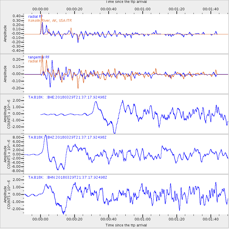
Signal To Noise
| Channel | StoN | STA | LTA |
| TA:B18K: :BHZ:20180329T21:37:17.92498Z | 35.81388 | 4.908123E-6 | 1.3704528E-7 |
| TA:B18K: :BHN:20180329T21:37:17.92498Z | 9.880469 | 8.4767953E-7 | 8.5793445E-8 |
| TA:B18K: :BHE:20180329T21:37:17.92498Z | 17.315445 | 1.1080102E-6 | 6.398971E-8 |
| Arrivals |
| Ps | 2.8 SECOND |
| PpPs | 9.3 SECOND |
| PsPs/PpSs | 12 SECOND |


