You are here: Home > Network List > TA - USArray Transportable Network (new EarthScope stations) Stations List
> Station G19K Purcell Mountains, AK, USA > Earthquake Result Viewer
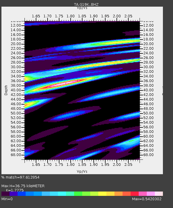
G19K Purcell Mountains, AK, USA - Earthquake Result Viewer
| Earthquake location: |
New Britain Region, P.N.G. |
| Earthquake latitude/longitude: |
-5.5/151.4 |
| Earthquake time(UTC): |
2018/03/29 (088) 21:25:32 GMT |
| Earthquake Depth: |
10 km |
| Earthquake Magnitude: |
6.9 mww |
| Earthquake Catalog/Contributor: |
NEIC PDE/us |
|
| Network: |
TA USArray Transportable Network (new EarthScope stations) |
| Station: |
G19K Purcell Mountains, AK, USA |
| Lat/Lon: |
66.14 N/157.09 W |
| Elevation: |
391 m |
|
| Distance: |
80.5 deg |
| Az: |
18.821 deg |
| Baz: |
232.149 deg |
| Ray Param: |
0.04825984 |
| Estimated Moho Depth: |
36.75 km |
| Estimated Crust Vp/Vs: |
1.78 |
| Assumed Crust Vp: |
6.577 km/s |
| Estimated Crust Vs: |
3.7 km/s |
| Estimated Crust Poisson's Ratio: |
0.27 |
|
| Radial Match: |
97.612854 % |
| Radial Bump: |
366 |
| Transverse Match: |
90.291016 % |
| Transverse Bump: |
400 |
| SOD ConfigId: |
13570011 |
| Insert Time: |
2019-04-30 00:59:19.843 +0000 |
| GWidth: |
2.5 |
| Max Bumps: |
400 |
| Tol: |
0.001 |
|

Signal To Noise
| Channel | StoN | STA | LTA |
| TA:G19K: :BHZ:20180329T21:37:14.04998Z | 56.42602 | 4.7949743E-6 | 8.497806E-8 |
| TA:G19K: :BHN:20180329T21:37:14.04998Z | 12.892162 | 1.1337158E-6 | 8.793838E-8 |
| TA:G19K: :BHE:20180329T21:37:14.04998Z | 29.63507 | 1.5720051E-6 | 5.3045433E-8 |
| Arrivals |
| Ps | 4.5 SECOND |
| PpPs | 15 SECOND |
| PsPs/PpSs | 20 SECOND |


