You are here: Home > Network List > TA - USArray Transportable Network (new EarthScope stations) Stations List
> Station H29M Whitestone, YT, CAN > Earthquake Result Viewer
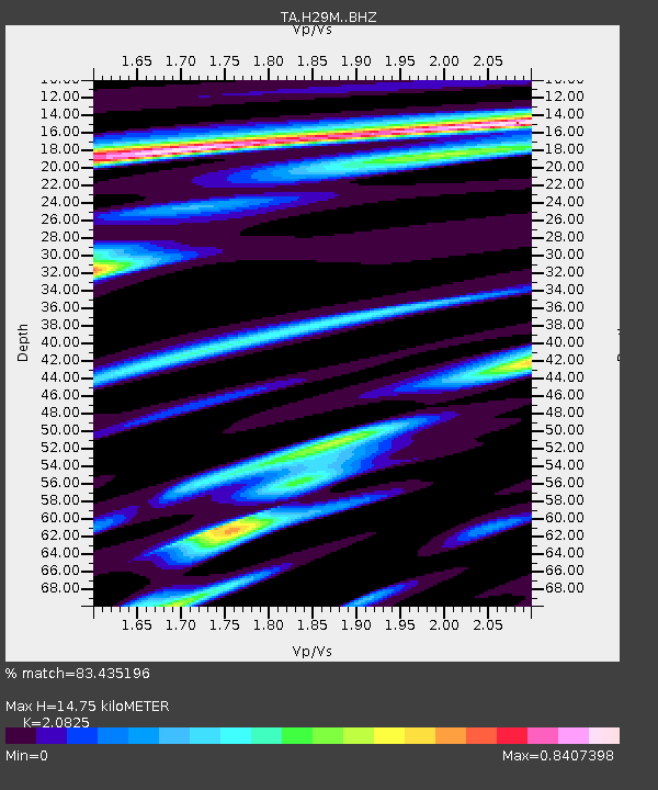
H29M Whitestone, YT, CAN - Earthquake Result Viewer
| Earthquake location: |
New Britain Region, P.N.G. |
| Earthquake latitude/longitude: |
-5.5/151.4 |
| Earthquake time(UTC): |
2018/03/29 (088) 21:25:32 GMT |
| Earthquake Depth: |
10 km |
| Earthquake Magnitude: |
6.9 mww |
| Earthquake Catalog/Contributor: |
NEIC PDE/us |
|
| Network: |
TA USArray Transportable Network (new EarthScope stations) |
| Station: |
H29M Whitestone, YT, CAN |
| Lat/Lon: |
66.22 N/138.37 W |
| Elevation: |
480 m |
|
| Distance: |
87.1 deg |
| Az: |
22.456 deg |
| Baz: |
249.673 deg |
| Ray Param: |
0.04355395 |
| Estimated Moho Depth: |
14.75 km |
| Estimated Crust Vp/Vs: |
2.08 |
| Assumed Crust Vp: |
6.577 km/s |
| Estimated Crust Vs: |
3.158 km/s |
| Estimated Crust Poisson's Ratio: |
0.35 |
|
| Radial Match: |
83.435196 % |
| Radial Bump: |
400 |
| Transverse Match: |
75.80962 % |
| Transverse Bump: |
400 |
| SOD ConfigId: |
13570011 |
| Insert Time: |
2019-04-30 00:59:38.514 +0000 |
| GWidth: |
2.5 |
| Max Bumps: |
400 |
| Tol: |
0.001 |
|

Signal To Noise
| Channel | StoN | STA | LTA |
| TA:H29M: :BHZ:20180329T21:37:47.900017Z | 23.639082 | 4.69387E-6 | 1.9856397E-7 |
| TA:H29M: :BHN:20180329T21:37:47.900017Z | 2.2532 | 3.98999E-7 | 1.7708103E-7 |
| TA:H29M: :BHE:20180329T21:37:47.900017Z | 9.725829 | 1.1602726E-6 | 1.1929806E-7 |
| Arrivals |
| Ps | 2.5 SECOND |
| PpPs | 6.8 SECOND |
| PsPs/PpSs | 9.3 SECOND |


