You are here: Home > Network List > TA - USArray Transportable Network (new EarthScope stations) Stations List
> Station M15K Kasigluk River, AK, USA > Earthquake Result Viewer
M15K Kasigluk River, AK, USA - Earthquake Result Viewer
| Earthquake location: |
New Britain Region, P.N.G. |
| Earthquake latitude/longitude: |
-5.5/151.4 |
| Earthquake time(UTC): |
2018/03/29 (088) 21:25:32 GMT |
| Earthquake Depth: |
10 km |
| Earthquake Magnitude: |
6.9 mww |
| Earthquake Catalog/Contributor: |
NEIC PDE/us |
|
| Network: |
TA USArray Transportable Network (new EarthScope stations) |
| Station: |
M15K Kasigluk River, AK, USA |
| Lat/Lon: |
60.69 N/160.69 W |
| Elevation: |
210 m |
|
| Distance: |
75.8 deg |
| Az: |
22.11 deg |
| Baz: |
229.607 deg |
| Ray Param: |
0.051455934 |
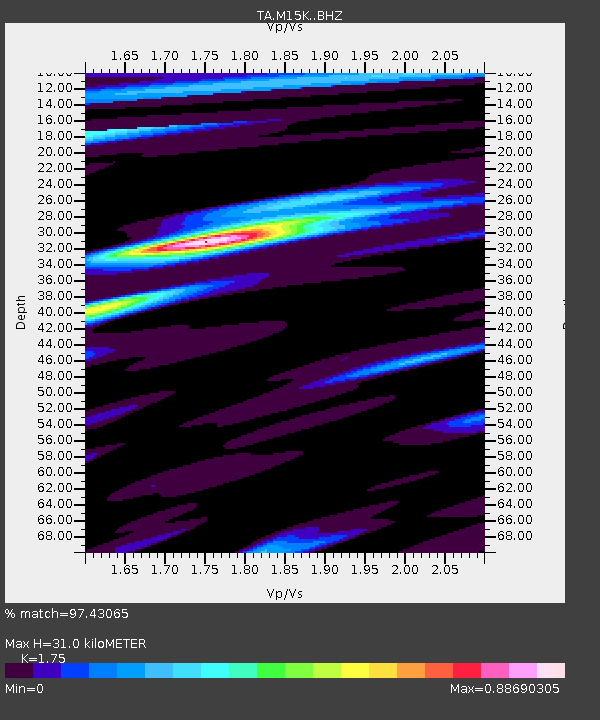
| Estimated Moho Depth: |
31.0 km |
| Estimated Crust Vp/Vs: |
1.75 |
| Assumed Crust Vp: |
6.182 km/s |
| Estimated Crust Vs: |
3.533 km/s |
| Estimated Crust Poisson's Ratio: |
0.26 |
|
| Radial Match: |
97.43065 % |
| Radial Bump: |
283 |
| Transverse Match: |
89.85155 % |
| Transverse Bump: |
400 |
| SOD ConfigId: |
13570011 |
| Insert Time: |
2019-04-30 01:00:16.356 +0000 |
| GWidth: |
2.5 |
| Max Bumps: |
400 |
| Tol: |
0.001 |
|

Signal To Noise
| Channel | StoN | STA | LTA |
| TA:M15K: :BHZ:20180329T21:36:48.025017Z | 48.155746 | 4.590689E-6 | 9.533004E-8 |
| TA:M15K: :BHN:20180329T21:36:48.025017Z | 19.502445 | 1.3257862E-6 | 6.7980515E-8 |
| TA:M15K: :BHE:20180329T21:36:48.025017Z | 13.08395 | 1.6437828E-6 | 1.2563352E-7 |
| Arrivals |
| Ps | 3.9 SECOND |
| PpPs | 13 SECOND |
| PsPs/PpSs | 17 SECOND |


