You are here: Home > Network List > TA - USArray Transportable Network (new EarthScope stations) Stations List
> Station F10A Beach Ranch, Enterprise, OR, USA > Earthquake Result Viewer
F10A Beach Ranch, Enterprise, OR, USA - Earthquake Result Viewer
| Earthquake location: |
Near Coast Of Chiapas, Mexico |
| Earthquake latitude/longitude: |
14.4/-92.4 |
| Earthquake time(UTC): |
2008/10/16 (290) 19:41:25 GMT |
| Earthquake Depth: |
24 km |
| Earthquake Magnitude: |
6.1 MB, 6.6 MS, 6.7 MW, 6.6 MW |
| Earthquake Catalog/Contributor: |
WHDF/NEIC |
|
| Network: |
TA USArray Transportable Network (new EarthScope stations) |
| Station: |
F10A Beach Ranch, Enterprise, OR, USA |
| Lat/Lon: |
45.97 N/117.23 W |
| Elevation: |
1136 m |
|
| Distance: |
37.8 deg |
| Az: |
331.397 deg |
| Baz: |
138.311 deg |
| Ray Param: |
0.07591014 |
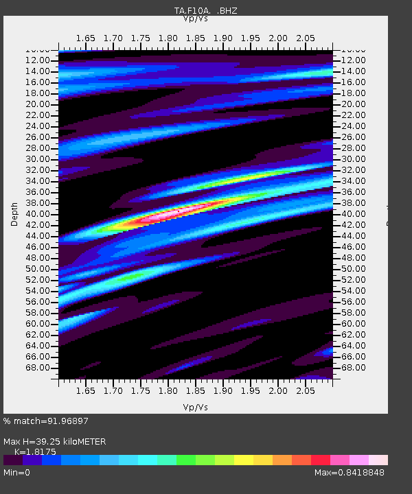
| Estimated Moho Depth: |
39.25 km |
| Estimated Crust Vp/Vs: |
1.82 |
| Assumed Crust Vp: |
6.571 km/s |
| Estimated Crust Vs: |
3.615 km/s |
| Estimated Crust Poisson's Ratio: |
0.28 |
|
| Radial Match: |
91.96897 % |
| Radial Bump: |
378 |
| Transverse Match: |
79.687706 % |
| Transverse Bump: |
400 |
| SOD ConfigId: |
2560 |
| Insert Time: |
2010-03-06 10:10:59.227 +0000 |
| GWidth: |
2.5 |
| Max Bumps: |
400 |
| Tol: |
0.001 |
|

Signal To Noise
| Channel | StoN | STA | LTA |
| TA:F10A: :BHZ:20081016T19:48:09.123992Z | 11.752382 | 3.4771838E-6 | 2.9587056E-7 |
| TA:F10A: :BHN:20081016T19:48:09.123992Z | 4.678745 | 1.2959263E-6 | 2.769816E-7 |
| TA:F10A: :BHE:20081016T19:48:09.123992Z | 7.2193384 | 1.7577253E-6 | 2.4347457E-7 |
| Arrivals |
| Ps | 5.3 SECOND |
| PpPs | 16 SECOND |
| PsPs/PpSs | 21 SECOND |


