You are here: Home > Network List > TA - USArray Transportable Network (new EarthScope stations) Stations List
> Station F10A Beach Ranch, Enterprise, OR, USA > Earthquake Result Viewer
F10A Beach Ranch, Enterprise, OR, USA - Earthquake Result Viewer
| Earthquake location: |
Vanuatu Islands |
| Earthquake latitude/longitude: |
-13.5/167.0 |
| Earthquake time(UTC): |
2008/09/08 (252) 18:52:06 GMT |
| Earthquake Depth: |
110 km |
| Earthquake Magnitude: |
6.4 MB, 6.9 MW, 6.9 MW |
| Earthquake Catalog/Contributor: |
WHDF/NEIC |
|
| Network: |
TA USArray Transportable Network (new EarthScope stations) |
| Station: |
F10A Beach Ranch, Enterprise, OR, USA |
| Lat/Lon: |
45.97 N/117.23 W |
| Elevation: |
1136 m |
|
| Distance: |
90.0 deg |
| Az: |
42.54 deg |
| Baz: |
250.565 deg |
| Ray Param: |
0.041683104 |
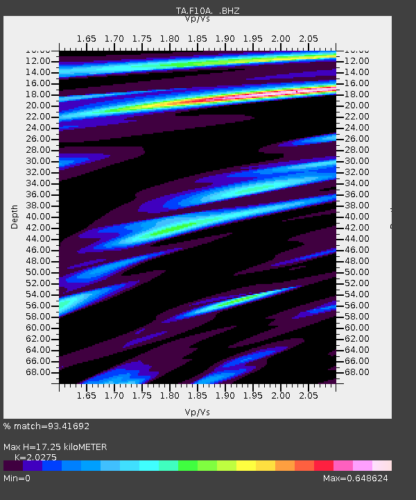
| Estimated Moho Depth: |
17.25 km |
| Estimated Crust Vp/Vs: |
2.03 |
| Assumed Crust Vp: |
6.571 km/s |
| Estimated Crust Vs: |
3.241 km/s |
| Estimated Crust Poisson's Ratio: |
0.34 |
|
| Radial Match: |
93.41692 % |
| Radial Bump: |
319 |
| Transverse Match: |
90.92896 % |
| Transverse Bump: |
400 |
| SOD ConfigId: |
2504 |
| Insert Time: |
2010-03-06 10:11:01.413 +0000 |
| GWidth: |
2.5 |
| Max Bumps: |
400 |
| Tol: |
0.001 |
|
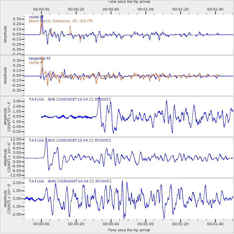
Signal To Noise
| Channel | StoN | STA | LTA |
| TA:F10A: :BHZ:20080908T19:04:22.850005Z | 51.16312 | 5.9893387E-6 | 1.17063585E-7 |
| TA:F10A: :BHN:20080908T19:04:22.850005Z | 5.2082157 | 5.8664347E-7 | 1.1263809E-7 |
| TA:F10A: :BHE:20080908T19:04:22.850005Z | 12.611028 | 1.6772108E-6 | 1.3299557E-7 |
| Arrivals |
| Ps | 2.7 SECOND |
| PpPs | 7.8 SECOND |
| PsPs/PpSs | 11 SECOND |


