You are here: Home > Network List > IU - Global Seismograph Network (GSN - IRIS/USGS) Stations List
> Station SLBS Sierra la Laguna Baja California Sur, Mexico > Earthquake Result Viewer
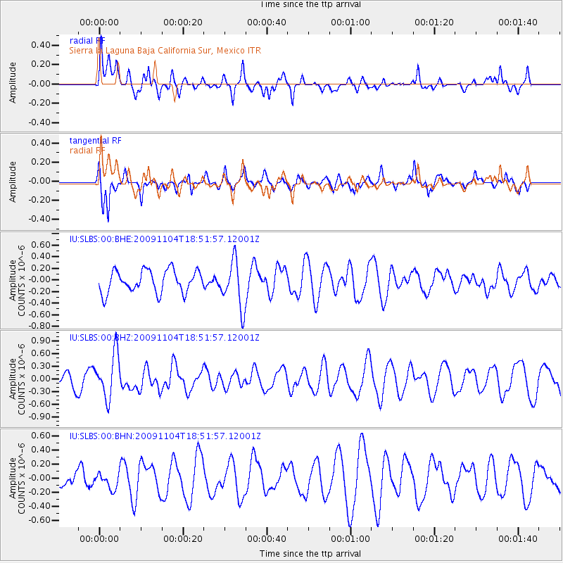
SLBS Sierra la Laguna Baja California Sur, Mexico - Earthquake Result Viewer
*The percent match for this event was below the threshold and hence no stack was calculated.
| Earthquake location: |
Azores Islands Region |
| Earthquake latitude/longitude: |
36.2/-33.9 |
| Earthquake time(UTC): |
2009/11/04 (308) 18:41:44 GMT |
| Earthquake Depth: |
10 km |
| Earthquake Magnitude: |
5.7 MB, 5.6 MS, 5.9 MW, 5.8 MW |
| Earthquake Catalog/Contributor: |
WHDF/NEIC |
|
| Network: |
IU Global Seismograph Network (GSN - IRIS/USGS) |
| Station: |
SLBS Sierra la Laguna Baja California Sur, Mexico |
| Lat/Lon: |
23.69 N/109.94 W |
| Elevation: |
825 m |
|
| Distance: |
65.6 deg |
| Az: |
282.279 deg |
| Baz: |
59.611 deg |
| Ray Param: |
$rayparam |
*The percent match for this event was below the threshold and hence was not used in the summary stack. |
|
| Radial Match: |
65.13549 % |
| Radial Bump: |
400 |
| Transverse Match: |
57.81402 % |
| Transverse Bump: |
345 |
| SOD ConfigId: |
1 |
| Insert Time: |
2010-02-19 01:04:17.553 +0000 |
| GWidth: |
2.5 |
| Max Bumps: |
400 |
| Tol: |
0.001 |
|
Signal To Noise
| Channel | StoN | STA | LTA |
| IU:SLBS:00:BHZ:20091104T18:51:57.12001Z | 2.3538277 | 5.366769E-7 | 2.2800178E-7 |
| IU:SLBS:00:BHN:20091104T18:51:57.12001Z | 0.8163572 | 1.15120464E-7 | 1.4101727E-7 |
| IU:SLBS:00:BHE:20091104T18:51:57.12001Z | 2.1738944 | 4.1693306E-7 | 1.9179086E-7 |
| Arrivals |
| Ps | |
| PpPs | |
| PsPs/PpSs | |


