You are here: Home > Network List > CI - Caltech Regional Seismic Network Stations List
> Station JCS Julian Camp Stevens, California, USA > Earthquake Result Viewer
JCS Julian Camp Stevens, California, USA - Earthquake Result Viewer

| Earthquake location: |
South Of Fiji Islands |
| Earthquake latitude/longitude: |
-23.9/178.5 |
| Earthquake time(UTC): |
2002/08/19 (231) 11:08:24 GMT |
| Earthquake Depth: |
675 km |
| Earthquake Magnitude: |
7.0 MB, 7.7 MW, 7.4 ME |
| Earthquake Catalog/Contributor: |
WHDF/NEIC |
|
| Network: |
CI Caltech Regional Seismic Network |
| Station: |
JCS Julian Camp Stevens, California, USA |
| Lat/Lon: |
33.09 N/116.60 W |
| Elevation: |
1258 m |
|
| Distance: |
83.9 deg |
| Az: |
49.881 deg |
| Baz: |
236.49 deg |
| Ray Param: |
0.043816406 |
| Estimated Moho Depth: |
33.75 km |
| Estimated Crust Vp/Vs: |
1.83 |
| Assumed Crust Vp: |
6.264 km/s |
| Estimated Crust Vs: |
3.432 km/s |
| Estimated Crust Poisson's Ratio: |
0.29 |
|
| Radial Match: |
81.59749 % |
| Radial Bump: |
400 |
| Transverse Match: |
66.34946 % |
| Transverse Bump: |
400 |
| SOD ConfigId: |
3770 |
| Insert Time: |
2010-02-26 01:53:26.892 +0000 |
| GWidth: |
2.5 |
| Max Bumps: |
400 |
| Tol: |
0.001 |
|
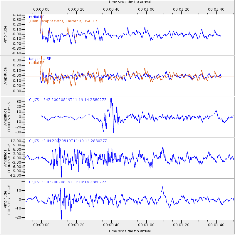
Signal To Noise
| Channel | StoN | STA | LTA |
| CI:JCS: :BHN:20020819T11:19:14.288027Z | 1.0330501 | 1.4590481E-6 | 1.4123692E-6 |
| CI:JCS: :BHE:20020819T11:19:14.288027Z | 1.3580834 | 2.4504573E-6 | 1.8043496E-6 |
| CI:JCS: :BHZ:20020819T11:19:14.288027Z | 2.1878679 | 4.8703273E-6 | 2.226061E-6 |
| Arrivals |
| Ps | 4.5 SECOND |
| PpPs | 15 SECOND |
| PsPs/PpSs | 19 SECOND |


