You are here: Home > Network List > US - United States National Seismic Network Stations List
> Station LONY Lake Ozonia, New York, USA > Earthquake Result Viewer
LONY Lake Ozonia, New York, USA - Earthquake Result Viewer
| Earthquake location: |
Northern East Pacific Rise |
| Earthquake latitude/longitude: |
10.3/-103.8 |
| Earthquake time(UTC): |
2016/04/29 (120) 01:33:38 GMT |
| Earthquake Depth: |
10 km |
| Earthquake Magnitude: |
6.8 MWP, 6.9 MI |
| Earthquake Catalog/Contributor: |
NEIC PDE/NEIC COMCAT |
|
| Network: |
US United States National Seismic Network |
| Station: |
LONY Lake Ozonia, New York, USA |
| Lat/Lon: |
44.62 N/74.58 W |
| Elevation: |
440 m |
|
| Distance: |
42.5 deg |
| Az: |
31.031 deg |
| Baz: |
225.274 deg |
| Ray Param: |
0.07314806 |
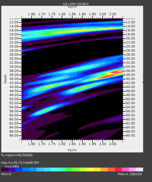
| Estimated Moho Depth: |
35.75 km |
| Estimated Crust Vp/Vs: |
2.10 |
| Assumed Crust Vp: |
6.419 km/s |
| Estimated Crust Vs: |
3.064 km/s |
| Estimated Crust Poisson's Ratio: |
0.35 |
|
| Radial Match: |
96.55688 % |
| Radial Bump: |
204 |
| Transverse Match: |
88.11856 % |
| Transverse Bump: |
339 |
| SOD ConfigId: |
1475611 |
| Insert Time: |
2016-05-13 01:41:51.647 +0000 |
| GWidth: |
2.5 |
| Max Bumps: |
400 |
| Tol: |
0.001 |
|
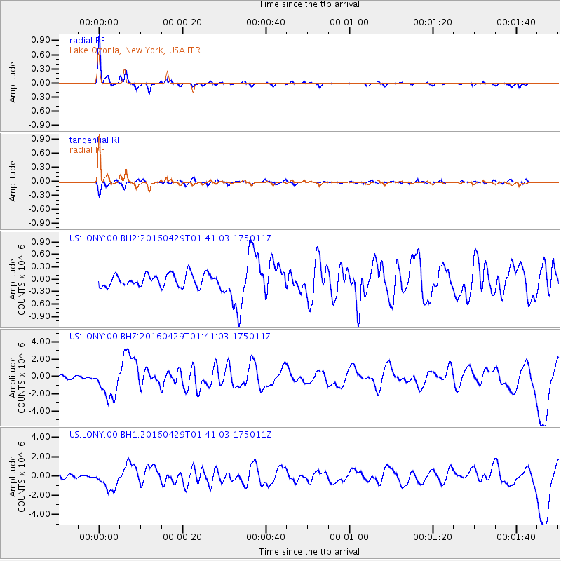
Signal To Noise
| Channel | StoN | STA | LTA |
| US:LONY:00:BHZ:20160429T01:41:03.175011Z | 9.139907 | 1.8212029E-6 | 1.9925835E-7 |
| US:LONY:00:BH1:20160429T01:41:03.175011Z | 4.204656 | 1.0791365E-6 | 2.5665273E-7 |
| US:LONY:00:BH2:20160429T01:41:03.175011Z | 3.6462932 | 5.299984E-7 | 1.4535264E-7 |
| Arrivals |
| Ps | 6.5 SECOND |
| PpPs | 16 SECOND |
| PsPs/PpSs | 23 SECOND |


