You are here: Home > Network List > US - United States National Seismic Network Stations List
> Station OGNE Ogallala, Nebraska, USA > Earthquake Result Viewer
OGNE Ogallala, Nebraska, USA - Earthquake Result Viewer

| Earthquake location: |
Northern East Pacific Rise |
| Earthquake latitude/longitude: |
10.3/-103.8 |
| Earthquake time(UTC): |
2016/04/29 (120) 01:33:38 GMT |
| Earthquake Depth: |
10 km |
| Earthquake Magnitude: |
6.8 MWP, 6.9 MI |
| Earthquake Catalog/Contributor: |
NEIC PDE/NEIC COMCAT |
|
| Network: |
US United States National Seismic Network |
| Station: |
OGNE Ogallala, Nebraska, USA |
| Lat/Lon: |
40.95 N/102.03 W |
| Elevation: |
1054 m |
|
| Distance: |
30.6 deg |
| Az: |
2.572 deg |
| Baz: |
183.343 deg |
| Ray Param: |
0.07928718 |
| Estimated Moho Depth: |
18.0 km |
| Estimated Crust Vp/Vs: |
1.66 |
| Assumed Crust Vp: |
6.483 km/s |
| Estimated Crust Vs: |
3.911 km/s |
| Estimated Crust Poisson's Ratio: |
0.21 |
|
| Radial Match: |
91.9469 % |
| Radial Bump: |
372 |
| Transverse Match: |
69.824104 % |
| Transverse Bump: |
374 |
| SOD ConfigId: |
1475611 |
| Insert Time: |
2016-05-13 01:42:08.350 +0000 |
| GWidth: |
2.5 |
| Max Bumps: |
400 |
| Tol: |
0.001 |
|
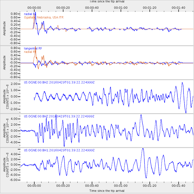
Signal To Noise
| Channel | StoN | STA | LTA |
| US:OGNE:00:BHZ:20160429T01:39:22.224999Z | 12.39716 | 1.6270251E-6 | 1.3124176E-7 |
| US:OGNE:00:BH1:20160429T01:39:22.224999Z | 3.7941864 | 1.1099007E-6 | 2.9252666E-7 |
| US:OGNE:00:BH2:20160429T01:39:22.224999Z | 1.1688217 | 4.414579E-7 | 3.7769482E-7 |
| Arrivals |
| Ps | 2.0 SECOND |
| PpPs | 6.8 SECOND |
| PsPs/PpSs | 8.8 SECOND |


