You are here: Home > Network List > UW - Pacific Northwest Regional Seismic Network Stations List
> Station KREP White Salmon, WA, USA > Earthquake Result Viewer
KREP White Salmon, WA, USA - Earthquake Result Viewer
| Earthquake location: |
New Britain Region, P.N.G. |
| Earthquake latitude/longitude: |
-5.5/151.4 |
| Earthquake time(UTC): |
2018/03/29 (088) 21:25:32 GMT |
| Earthquake Depth: |
10 km |
| Earthquake Magnitude: |
6.9 mww |
| Earthquake Catalog/Contributor: |
NEIC PDE/us |
|
| Network: |
UW Pacific Northwest Regional Seismic Network |
| Station: |
KREP White Salmon, WA, USA |
| Lat/Lon: |
45.89 N/121.46 W |
| Elevation: |
472 m |
|
| Distance: |
91.9 deg |
| Az: |
44.265 deg |
| Baz: |
264.123 deg |
| Ray Param: |
0.041545328 |
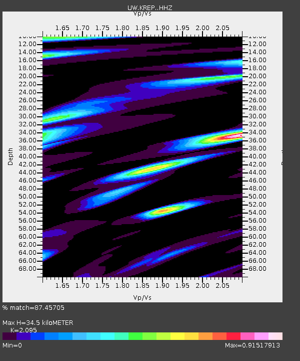
| Estimated Moho Depth: |
34.5 km |
| Estimated Crust Vp/Vs: |
2.10 |
| Assumed Crust Vp: |
6.597 km/s |
| Estimated Crust Vs: |
3.149 km/s |
| Estimated Crust Poisson's Ratio: |
0.35 |
|
| Radial Match: |
87.45705 % |
| Radial Bump: |
400 |
| Transverse Match: |
76.0832 % |
| Transverse Bump: |
400 |
| SOD ConfigId: |
13570011 |
| Insert Time: |
2019-04-30 01:01:57.703 +0000 |
| GWidth: |
2.5 |
| Max Bumps: |
400 |
| Tol: |
0.001 |
|

Signal To Noise
| Channel | StoN | STA | LTA |
| UW:KREP: :HHZ:20180329T21:38:09.989983Z | 21.030397 | 3.0358567E-6 | 1.4435565E-7 |
| UW:KREP: :HHN:20180329T21:38:09.989983Z | 2.075477 | 4.413145E-7 | 2.1263283E-7 |
| UW:KREP: :HHE:20180329T21:38:09.989983Z | 5.6729984 | 8.673199E-7 | 1.5288563E-7 |
| Arrivals |
| Ps | 5.8 SECOND |
| PpPs | 16 SECOND |
| PsPs/PpSs | 22 SECOND |


