You are here: Home > Network List > TA - USArray Transportable Network (new EarthScope stations) Stations List
> Station F10A Beach Ranch, Enterprise, OR, USA > Earthquake Result Viewer
F10A Beach Ranch, Enterprise, OR, USA - Earthquake Result Viewer
| Earthquake location: |
Andreanof Islands, Aleutian Is. |
| Earthquake latitude/longitude: |
50.2/-177.6 |
| Earthquake time(UTC): |
2007/08/16 (228) 04:03:03 GMT |
| Earthquake Depth: |
15 km |
| Earthquake Magnitude: |
5.8 MB |
| Earthquake Catalog/Contributor: |
WHDF/NEIC |
|
| Network: |
TA USArray Transportable Network (new EarthScope stations) |
| Station: |
F10A Beach Ranch, Enterprise, OR, USA |
| Lat/Lon: |
45.97 N/117.23 W |
| Elevation: |
1136 m |
|
| Distance: |
39.6 deg |
| Az: |
72.114 deg |
| Baz: |
298.817 deg |
| Ray Param: |
0.07490561 |
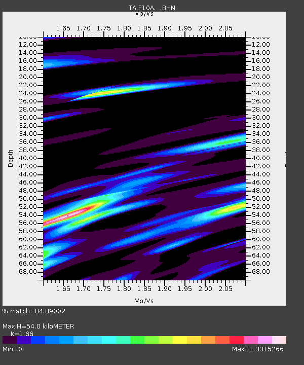
| Estimated Moho Depth: |
54.0 km |
| Estimated Crust Vp/Vs: |
1.66 |
| Assumed Crust Vp: |
6.571 km/s |
| Estimated Crust Vs: |
3.958 km/s |
| Estimated Crust Poisson's Ratio: |
0.22 |
|
| Radial Match: |
84.89002 % |
| Radial Bump: |
393 |
| Transverse Match: |
56.986485 % |
| Transverse Bump: |
379 |
| SOD ConfigId: |
2564 |
| Insert Time: |
2010-03-06 10:11:47.096 +0000 |
| GWidth: |
2.5 |
| Max Bumps: |
400 |
| Tol: |
0.001 |
|

Signal To Noise
| Channel | StoN | STA | LTA |
| TA:F10A: :BHN:20070816T04:10:03.049011Z | 2.6116555 | 4.873158E-7 | 1.8659267E-7 |
| TA:F10A: :BHE:20070816T04:10:03.049011Z | 2.5590773 | 5.2282684E-7 | 2.0430288E-7 |
| TA:F10A: :BHZ:20070816T04:10:03.049011Z | 4.1928596 | 8.886224E-7 | 2.1193709E-7 |
| Arrivals |
| Ps | 5.9 SECOND |
| PpPs | 20 SECOND |
| PsPs/PpSs | 26 SECOND |


