You are here: Home > Network List > XV14 - Fault Locations and Alaska Tectonics from Seismicity Stations List
> Station FTGH Toghotthele, Parks Hwy, AK, USA > Earthquake Result Viewer
FTGH Toghotthele, Parks Hwy, AK, USA - Earthquake Result Viewer
| Earthquake location: |
New Britain Region, P.N.G. |
| Earthquake latitude/longitude: |
-5.5/151.4 |
| Earthquake time(UTC): |
2018/03/29 (088) 21:25:32 GMT |
| Earthquake Depth: |
10 km |
| Earthquake Magnitude: |
6.9 mww |
| Earthquake Catalog/Contributor: |
NEIC PDE/us |
|
| Network: |
XV Fault Locations and Alaska Tectonics from Seismicity |
| Station: |
FTGH Toghotthele, Parks Hwy, AK, USA |
| Lat/Lon: |
64.69 N/148.83 W |
| Elevation: |
286 m |
|
| Distance: |
82.5 deg |
| Az: |
21.987 deg |
| Baz: |
240.122 deg |
| Ray Param: |
0.04683108 |
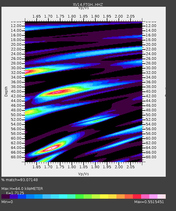
| Estimated Moho Depth: |
64.0 km |
| Estimated Crust Vp/Vs: |
1.71 |
| Assumed Crust Vp: |
6.566 km/s |
| Estimated Crust Vs: |
3.834 km/s |
| Estimated Crust Poisson's Ratio: |
0.24 |
|
| Radial Match: |
93.07148 % |
| Radial Bump: |
400 |
| Transverse Match: |
81.82535 % |
| Transverse Bump: |
400 |
| SOD ConfigId: |
13570011 |
| Insert Time: |
2019-04-30 01:02:39.460 +0000 |
| GWidth: |
2.5 |
| Max Bumps: |
400 |
| Tol: |
0.001 |
|

Signal To Noise
| Channel | StoN | STA | LTA |
| XV:FTGH: :HHZ:20180329T21:37:24.850029Z | 42.073753 | 4.014346E-6 | 9.541212E-8 |
| XV:FTGH: :HHN:20180329T21:37:24.850029Z | 7.214781 | 8.386311E-7 | 1.16237906E-7 |
| XV:FTGH: :HHE:20180329T21:37:24.850029Z | 14.824507 | 1.2376272E-6 | 8.348522E-8 |
| Arrivals |
| Ps | 7.1 SECOND |
| PpPs | 26 SECOND |
| PsPs/PpSs | 33 SECOND |


