You are here: Home > Network List > TA - USArray Transportable Network (new EarthScope stations) Stations List
> Station F10A Beach Ranch, Enterprise, OR, USA > Earthquake Result Viewer
F10A Beach Ranch, Enterprise, OR, USA - Earthquake Result Viewer
| Earthquake location: |
Andreanof Islands, Aleutian Is. |
| Earthquake latitude/longitude: |
51.3/-180.0 |
| Earthquake time(UTC): |
2007/08/02 (214) 03:21:42 GMT |
| Earthquake Depth: |
21 km |
| Earthquake Magnitude: |
6.3 MB, 6.6 MS, 6.7 MW, 6.6 MW |
| Earthquake Catalog/Contributor: |
WHDF/NEIC |
|
| Network: |
TA USArray Transportable Network (new EarthScope stations) |
| Station: |
F10A Beach Ranch, Enterprise, OR, USA |
| Lat/Lon: |
45.97 N/117.23 W |
| Elevation: |
1136 m |
|
| Distance: |
40.7 deg |
| Az: |
72.018 deg |
| Baz: |
301.119 deg |
| Ray Param: |
0.07423189 |
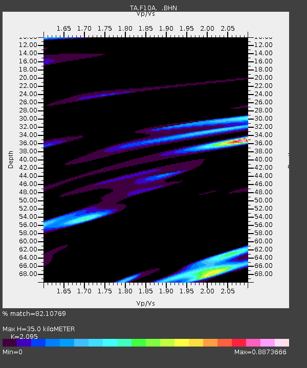
| Estimated Moho Depth: |
35.0 km |
| Estimated Crust Vp/Vs: |
2.10 |
| Assumed Crust Vp: |
6.571 km/s |
| Estimated Crust Vs: |
3.136 km/s |
| Estimated Crust Poisson's Ratio: |
0.35 |
|
| Radial Match: |
82.10769 % |
| Radial Bump: |
400 |
| Transverse Match: |
74.10545 % |
| Transverse Bump: |
400 |
| SOD ConfigId: |
2564 |
| Insert Time: |
2010-03-06 10:11:56.774 +0000 |
| GWidth: |
2.5 |
| Max Bumps: |
400 |
| Tol: |
0.001 |
|

Signal To Noise
| Channel | StoN | STA | LTA |
| TA:F10A: :BHN:20070802T03:28:50.848015Z | 2.1694825 | 1.3679418E-6 | 6.305383E-7 |
| TA:F10A: :BHE:20070802T03:28:50.848015Z | 3.284117 | 1.5921779E-6 | 4.8481155E-7 |
| TA:F10A: :BHZ:20070802T03:28:50.848015Z | 3.0073361 | 2.8557963E-6 | 9.4960996E-7 |
| Arrivals |
| Ps | 6.2 SECOND |
| PpPs | 16 SECOND |
| PsPs/PpSs | 22 SECOND |


