You are here: Home > Network List > TA - USArray Transportable Network (new EarthScope stations) Stations List
> Station J20K Nowitna River, AK, USA > Earthquake Result Viewer
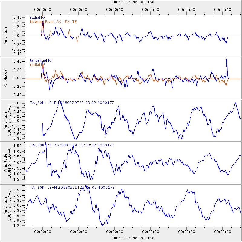
J20K Nowitna River, AK, USA - Earthquake Result Viewer
*The percent match for this event was below the threshold and hence no stack was calculated.
| Earthquake location: |
New Britain Region, P.N.G. |
| Earthquake latitude/longitude: |
-5.9/151.8 |
| Earthquake time(UTC): |
2018/03/29 (088) 22:51:24 GMT |
| Earthquake Depth: |
35 km |
| Earthquake Magnitude: |
5.9 Ms_20 |
| Earthquake Catalog/Contributor: |
NEIC PDE/us |
|
| Network: |
TA USArray Transportable Network (new EarthScope stations) |
| Station: |
J20K Nowitna River, AK, USA |
| Lat/Lon: |
64.18 N/154.15 W |
| Elevation: |
314 m |
|
| Distance: |
80.5 deg |
| Az: |
21.054 deg |
| Baz: |
234.683 deg |
| Ray Param: |
$rayparam |
*The percent match for this event was below the threshold and hence was not used in the summary stack. |
|
| Radial Match: |
50.205524 % |
| Radial Bump: |
400 |
| Transverse Match: |
65.12153 % |
| Transverse Bump: |
400 |
| SOD ConfigId: |
13570011 |
| Insert Time: |
2019-04-30 01:06:37.693 +0000 |
| GWidth: |
2.5 |
| Max Bumps: |
400 |
| Tol: |
0.001 |
|
Signal To Noise
| Channel | StoN | STA | LTA |
| TA:J20K: :BHZ:20180329T23:03:02.100017Z | 3.1632397 | 9.132655E-7 | 2.8871207E-7 |
| TA:J20K: :BHN:20180329T23:03:02.100017Z | 0.6079667 | 2.3843964E-7 | 3.9219194E-7 |
| TA:J20K: :BHE:20180329T23:03:02.100017Z | 0.66934526 | 3.3352552E-7 | 4.982862E-7 |
| Arrivals |
| Ps | |
| PpPs | |
| PsPs/PpSs | |


