You are here: Home > Network List > TA - USArray Transportable Network (new EarthScope stations) Stations List
> Station F10A Beach Ranch, Enterprise, OR, USA > Earthquake Result Viewer
F10A Beach Ranch, Enterprise, OR, USA - Earthquake Result Viewer
| Earthquake location: |
Sea Of Okhotsk |
| Earthquake latitude/longitude: |
54.2/154.3 |
| Earthquake time(UTC): |
2008/11/24 (329) 09:02:58 GMT |
| Earthquake Depth: |
492 km |
| Earthquake Magnitude: |
6.5 MB, 7.3 MW, 7.3 MW |
| Earthquake Catalog/Contributor: |
WHDF/NEIC |
|
| Network: |
TA USArray Transportable Network (new EarthScope stations) |
| Station: |
F10A Beach Ranch, Enterprise, OR, USA |
| Lat/Lon: |
45.97 N/117.23 W |
| Elevation: |
1136 m |
|
| Distance: |
53.8 deg |
| Az: |
59.798 deg |
| Baz: |
313.276 deg |
| Ray Param: |
0.06383482 |
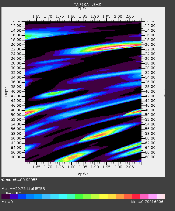
| Estimated Moho Depth: |
20.75 km |
| Estimated Crust Vp/Vs: |
2.01 |
| Assumed Crust Vp: |
6.571 km/s |
| Estimated Crust Vs: |
3.277 km/s |
| Estimated Crust Poisson's Ratio: |
0.33 |
|
| Radial Match: |
80.93955 % |
| Radial Bump: |
400 |
| Transverse Match: |
69.62606 % |
| Transverse Bump: |
400 |
| SOD ConfigId: |
2658 |
| Insert Time: |
2010-03-06 10:12:19.720 +0000 |
| GWidth: |
2.5 |
| Max Bumps: |
400 |
| Tol: |
0.001 |
|

Signal To Noise
| Channel | StoN | STA | LTA |
| TA:F10A: :BHZ:20081124T09:11:03.499014Z | 4.2521834 | 2.9943012E-6 | 7.041797E-7 |
| TA:F10A: :BHN:20081124T09:11:03.499014Z | 1.678275 | 1.0375021E-6 | 6.1819554E-7 |
| TA:F10A: :BHE:20081124T09:11:03.499014Z | 4.0153813 | 1.6062149E-6 | 4.0001555E-7 |
| Arrivals |
| Ps | 3.3 SECOND |
| PpPs | 9.1 SECOND |
| PsPs/PpSs | 12 SECOND |


