You are here: Home > Network List > TA - USArray Transportable Network (new EarthScope stations) Stations List
> Station O17K Koliganek, Bristol Bay, AK, USA > Earthquake Result Viewer
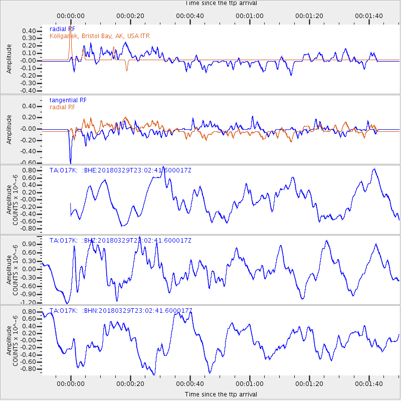
O17K Koliganek, Bristol Bay, AK, USA - Earthquake Result Viewer
*The percent match for this event was below the threshold and hence no stack was calculated.
| Earthquake location: |
New Britain Region, P.N.G. |
| Earthquake latitude/longitude: |
-5.9/151.8 |
| Earthquake time(UTC): |
2018/03/29 (088) 22:51:24 GMT |
| Earthquake Depth: |
35 km |
| Earthquake Magnitude: |
5.9 Ms_20 |
| Earthquake Catalog/Contributor: |
NEIC PDE/us |
|
| Network: |
TA USArray Transportable Network (new EarthScope stations) |
| Station: |
O17K Koliganek, Bristol Bay, AK, USA |
| Lat/Lon: |
59.77 N/157.09 W |
| Elevation: |
156 m |
|
| Distance: |
76.8 deg |
| Az: |
23.841 deg |
| Baz: |
232.63 deg |
| Ray Param: |
$rayparam |
*The percent match for this event was below the threshold and hence was not used in the summary stack. |
|
| Radial Match: |
59.459114 % |
| Radial Bump: |
400 |
| Transverse Match: |
69.27302 % |
| Transverse Bump: |
400 |
| SOD ConfigId: |
13570011 |
| Insert Time: |
2019-04-30 01:06:48.198 +0000 |
| GWidth: |
2.5 |
| Max Bumps: |
400 |
| Tol: |
0.001 |
|
Signal To Noise
| Channel | StoN | STA | LTA |
| TA:O17K: :BHZ:20180329T23:02:41.600017Z | 2.151174 | 6.594465E-7 | 3.0655193E-7 |
| TA:O17K: :BHN:20180329T23:02:41.600017Z | 0.8867266 | 5.859504E-7 | 6.608016E-7 |
| TA:O17K: :BHE:20180329T23:02:41.600017Z | 2.0174735 | 7.181826E-7 | 3.5598117E-7 |
| Arrivals |
| Ps | |
| PpPs | |
| PsPs/PpSs | |


