You are here: Home > Network List > TA - USArray Transportable Network (new EarthScope stations) Stations List
> Station F10A Beach Ranch, Enterprise, OR, USA > Earthquake Result Viewer
F10A Beach Ranch, Enterprise, OR, USA - Earthquake Result Viewer
| Earthquake location: |
East Of Kuril Islands |
| Earthquake latitude/longitude: |
44.1/154.7 |
| Earthquake time(UTC): |
2006/11/15 (319) 11:48:04 GMT |
| Earthquake Depth: |
10 km |
| Earthquake Magnitude: |
5.5 MB |
| Earthquake Catalog/Contributor: |
WHDF/NEIC |
|
| Network: |
TA USArray Transportable Network (new EarthScope stations) |
| Station: |
F10A Beach Ranch, Enterprise, OR, USA |
| Lat/Lon: |
45.97 N/117.23 W |
| Elevation: |
1136 m |
|
| Distance: |
59.1 deg |
| Az: |
54.344 deg |
| Baz: |
302.929 deg |
| Ray Param: |
0.0624303 |
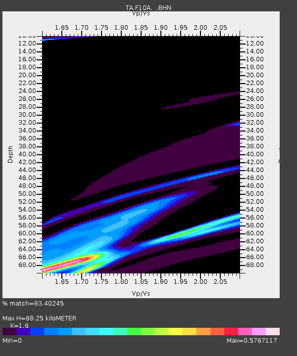
| Estimated Moho Depth: |
69.25 km |
| Estimated Crust Vp/Vs: |
1.60 |
| Assumed Crust Vp: |
6.571 km/s |
| Estimated Crust Vs: |
4.107 km/s |
| Estimated Crust Poisson's Ratio: |
0.18 |
|
| Radial Match: |
83.40245 % |
| Radial Bump: |
400 |
| Transverse Match: |
64.98534 % |
| Transverse Bump: |
319 |
| SOD ConfigId: |
2564 |
| Insert Time: |
2010-03-06 10:12:24.965 +0000 |
| GWidth: |
2.5 |
| Max Bumps: |
400 |
| Tol: |
0.001 |
|

Signal To Noise
| Channel | StoN | STA | LTA |
| TA:F10A: :BHN:20061115T11:57:33.37502Z | 1.4935997 | 6.430984E-5 | 4.3056945E-5 |
| TA:F10A: :BHE:20061115T11:57:33.37502Z | 0.6594188 | 4.2960113E-5 | 6.5148444E-5 |
| TA:F10A: :BHZ:20061115T11:57:33.37502Z | 1.6857201 | 1.1059045E-4 | 6.560428E-5 |
| Arrivals |
| Ps | 6.7 SECOND |
| PpPs | 26 SECOND |
| PsPs/PpSs | 33 SECOND |


