You are here: Home > Network List > TA - USArray Transportable Network (new EarthScope stations) Stations List
> Station F10A Beach Ranch, Enterprise, OR, USA > Earthquake Result Viewer
F10A Beach Ranch, Enterprise, OR, USA - Earthquake Result Viewer
| Earthquake location: |
Andreanof Islands, Aleutian Is. |
| Earthquake latitude/longitude: |
51.9/-179.4 |
| Earthquake time(UTC): |
2008/04/15 (106) 22:59:51 GMT |
| Earthquake Depth: |
10 km |
| Earthquake Magnitude: |
6.1 MB, 6.4 MS, 6.4 MW, 6.4 MW |
| Earthquake Catalog/Contributor: |
WHDF/NEIC |
|
| Network: |
TA USArray Transportable Network (new EarthScope stations) |
| Station: |
F10A Beach Ranch, Enterprise, OR, USA |
| Lat/Lon: |
45.97 N/117.23 W |
| Elevation: |
1136 m |
|
| Distance: |
40.1 deg |
| Az: |
72.975 deg |
| Baz: |
301.748 deg |
| Ray Param: |
0.07455818 |
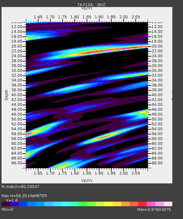
| Estimated Moho Depth: |
56.25 km |
| Estimated Crust Vp/Vs: |
1.60 |
| Assumed Crust Vp: |
6.571 km/s |
| Estimated Crust Vs: |
4.107 km/s |
| Estimated Crust Poisson's Ratio: |
0.18 |
|
| Radial Match: |
90.24547 % |
| Radial Bump: |
400 |
| Transverse Match: |
74.978226 % |
| Transverse Bump: |
400 |
| SOD ConfigId: |
2504 |
| Insert Time: |
2010-03-06 10:12:37.818 +0000 |
| GWidth: |
2.5 |
| Max Bumps: |
400 |
| Tol: |
0.001 |
|

Signal To Noise
| Channel | StoN | STA | LTA |
| TA:F10A: :BHZ:20080415T23:06:56.550012Z | 9.997726 | 1.0865876E-6 | 1.0868347E-7 |
| TA:F10A: :BHN:20080415T23:06:56.550012Z | 2.6666496 | 3.885707E-7 | 1.4571494E-7 |
| TA:F10A: :BHE:20080415T23:06:56.550012Z | 2.6214077 | 5.8441736E-7 | 2.2294027E-7 |
| Arrivals |
| Ps | 5.6 SECOND |
| PpPs | 21 SECOND |
| PsPs/PpSs | 26 SECOND |


