You are here: Home > Network List > CI - Caltech Regional Seismic Network Stations List
> Station JCS Julian Camp Stevens, California, USA > Earthquake Result Viewer
JCS Julian Camp Stevens, California, USA - Earthquake Result Viewer
| Earthquake location: |
Tonga Islands |
| Earthquake latitude/longitude: |
-15.1/-175.9 |
| Earthquake time(UTC): |
2002/06/21 (172) 14:21:44 GMT |
| Earthquake Depth: |
319 km |
| Earthquake Magnitude: |
5.7 MB, 5.7 MW, 5.7 MW |
| Earthquake Catalog/Contributor: |
WHDF/NEIC |
|
| Network: |
CI Caltech Regional Seismic Network |
| Station: |
JCS Julian Camp Stevens, California, USA |
| Lat/Lon: |
33.09 N/116.60 W |
| Elevation: |
1258 m |
|
| Distance: |
74.1 deg |
| Az: |
48.613 deg |
| Baz: |
239.674 deg |
| Ray Param: |
0.05164113 |
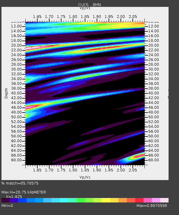
| Estimated Moho Depth: |
20.75 km |
| Estimated Crust Vp/Vs: |
1.62 |
| Assumed Crust Vp: |
6.264 km/s |
| Estimated Crust Vs: |
3.855 km/s |
| Estimated Crust Poisson's Ratio: |
0.20 |
|
| Radial Match: |
85.78575 % |
| Radial Bump: |
354 |
| Transverse Match: |
74.41099 % |
| Transverse Bump: |
399 |
| SOD ConfigId: |
3770 |
| Insert Time: |
2010-02-26 01:53:30.936 +0000 |
| GWidth: |
2.5 |
| Max Bumps: |
400 |
| Tol: |
0.001 |
|
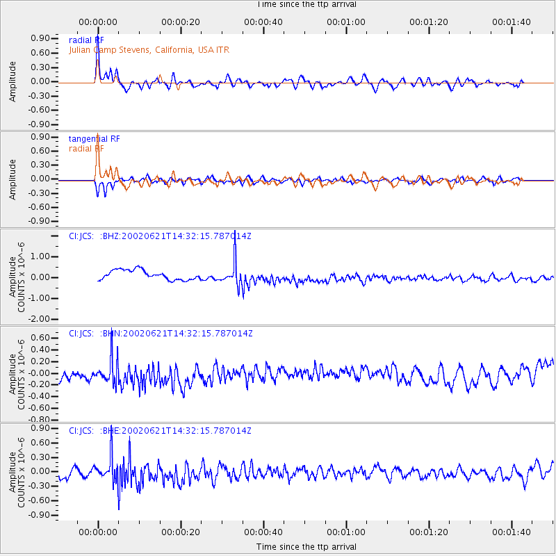
Signal To Noise
| Channel | StoN | STA | LTA |
| CI:JCS: :BHN:20020621T14:32:15.787014Z | 1.0612574 | 2.8330513E-7 | 2.6695233E-7 |
| CI:JCS: :BHE:20020621T14:32:15.787014Z | 1.3652568 | 2.6330187E-7 | 1.9285886E-7 |
| CI:JCS: :BHZ:20020621T14:32:15.787014Z | 2.484448 | 5.623534E-7 | 2.2634943E-7 |
| Arrivals |
| Ps | 2.1 SECOND |
| PpPs | 8.4 SECOND |
| PsPs/PpSs | 11 SECOND |


