You are here: Home > Network List > AV - Alaska Volcano Observatory Stations List
> Station AMKA Regional Station, Amchitka Island, Alaska > Earthquake Result Viewer
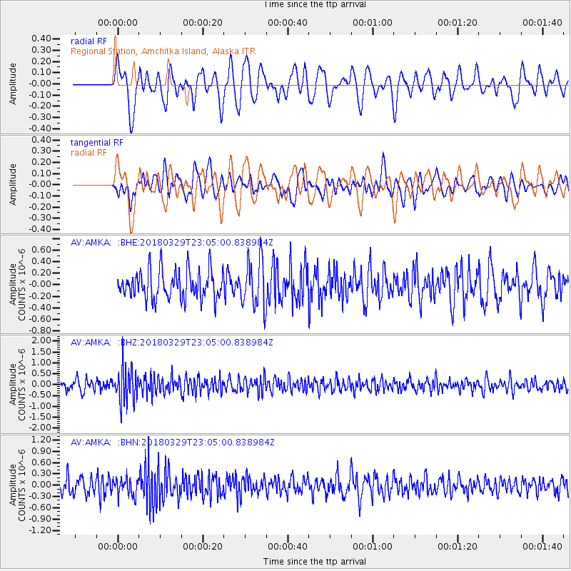
AMKA Regional Station, Amchitka Island, Alaska - Earthquake Result Viewer
*The percent match for this event was below the threshold and hence no stack was calculated.
| Earthquake location: |
Tajikistan |
| Earthquake latitude/longitude: |
38.7/70.0 |
| Earthquake time(UTC): |
2018/03/29 (088) 22:54:12 GMT |
| Earthquake Depth: |
3.6 km |
| Earthquake Magnitude: |
5.6 mb |
| Earthquake Catalog/Contributor: |
NEIC PDE/us |
|
| Network: |
AV Alaska Volcano Observatory |
| Station: |
AMKA Regional Station, Amchitka Island, Alaska |
| Lat/Lon: |
51.38 N/179.30 E |
| Elevation: |
116 m |
|
| Distance: |
71.1 deg |
| Az: |
38.674 deg |
| Baz: |
308.763 deg |
| Ray Param: |
$rayparam |
*The percent match for this event was below the threshold and hence was not used in the summary stack. |
|
| Radial Match: |
50.308315 % |
| Radial Bump: |
400 |
| Transverse Match: |
45.6427 % |
| Transverse Bump: |
400 |
| SOD ConfigId: |
13570011 |
| Insert Time: |
2019-04-30 01:08:34.049 +0000 |
| GWidth: |
2.5 |
| Max Bumps: |
400 |
| Tol: |
0.001 |
|
Signal To Noise
| Channel | StoN | STA | LTA |
| AV:AMKA: :BHZ:20180329T23:05:00.838984Z | 3.797751 | 7.855989E-7 | 2.0685899E-7 |
| AV:AMKA: :BHN:20180329T23:05:00.838984Z | 0.95823044 | 2.296771E-7 | 2.396888E-7 |
| AV:AMKA: :BHE:20180329T23:05:00.838984Z | 1.7595407 | 4.2920504E-7 | 2.4393017E-7 |
| Arrivals |
| Ps | |
| PpPs | |
| PsPs/PpSs | |


