You are here: Home > Network List > TA - USArray Transportable Network (new EarthScope stations) Stations List
> Station F10A Beach Ranch, Enterprise, OR, USA > Earthquake Result Viewer
F10A Beach Ranch, Enterprise, OR, USA - Earthquake Result Viewer
| Earthquake location: |
Ryukyu Islands, Japan |
| Earthquake latitude/longitude: |
27.5/128.3 |
| Earthquake time(UTC): |
2008/07/08 (190) 07:42:10 GMT |
| Earthquake Depth: |
43 km |
| Earthquake Magnitude: |
6.0 MB, 5.5 MS, 6.0 MW, 6.0 MW |
| Earthquake Catalog/Contributor: |
WHDF/NEIC |
|
| Network: |
TA USArray Transportable Network (new EarthScope stations) |
| Station: |
F10A Beach Ranch, Enterprise, OR, USA |
| Lat/Lon: |
45.97 N/117.23 W |
| Elevation: |
1136 m |
|
| Distance: |
85.8 deg |
| Az: |
39.541 deg |
| Baz: |
305.841 deg |
| Ray Param: |
0.044441886 |
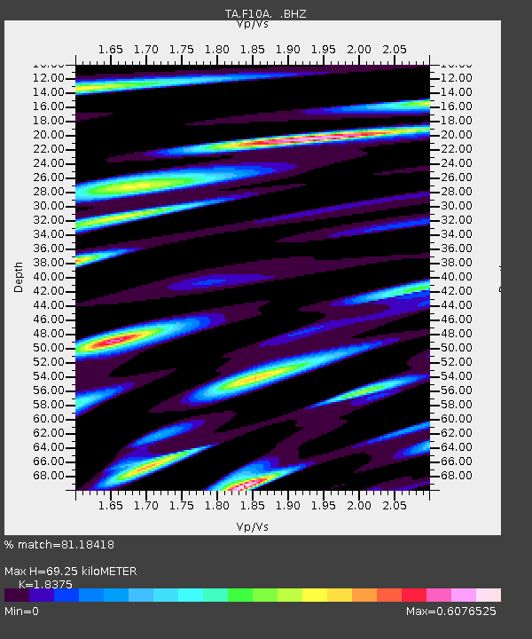
| Estimated Moho Depth: |
69.25 km |
| Estimated Crust Vp/Vs: |
1.84 |
| Assumed Crust Vp: |
6.571 km/s |
| Estimated Crust Vs: |
3.576 km/s |
| Estimated Crust Poisson's Ratio: |
0.29 |
|
| Radial Match: |
81.18418 % |
| Radial Bump: |
400 |
| Transverse Match: |
77.88137 % |
| Transverse Bump: |
400 |
| SOD ConfigId: |
2504 |
| Insert Time: |
2010-03-06 10:12:52.823 +0000 |
| GWidth: |
2.5 |
| Max Bumps: |
400 |
| Tol: |
0.001 |
|
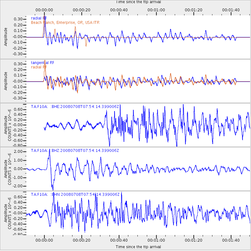
Signal To Noise
| Channel | StoN | STA | LTA |
| TA:F10A: :BHZ:20080708T07:54:14.399006Z | 15.945801 | 1.1950187E-6 | 7.494254E-8 |
| TA:F10A: :BHN:20080708T07:54:14.399006Z | 3.2716684 | 2.4094598E-7 | 7.364621E-8 |
| TA:F10A: :BHE:20080708T07:54:14.399006Z | 2.9669108 | 2.611526E-7 | 8.8021714E-8 |
| Arrivals |
| Ps | 9.0 SECOND |
| PpPs | 29 SECOND |
| PsPs/PpSs | 38 SECOND |


