You are here: Home > Network List > WI - West Indies IPGP Network Stations List
> Station TDBA Terre de Bas, Les Saintes > Earthquake Result Viewer
TDBA Terre de Bas, Les Saintes - Earthquake Result Viewer
| Earthquake location: |
Northern East Pacific Rise |
| Earthquake latitude/longitude: |
10.3/-103.8 |
| Earthquake time(UTC): |
2016/04/29 (120) 01:33:38 GMT |
| Earthquake Depth: |
10 km |
| Earthquake Magnitude: |
6.8 MWP, 6.9 MI |
| Earthquake Catalog/Contributor: |
NEIC PDE/NEIC COMCAT |
|
| Network: |
WI West Indies IPGP Network |
| Station: |
TDBA Terre de Bas, Les Saintes |
| Lat/Lon: |
15.85 N/61.64 W |
| Elevation: |
176 m |
|
| Distance: |
41.4 deg |
| Az: |
77.677 deg |
| Baz: |
267.569 deg |
| Ray Param: |
0.07384089 |
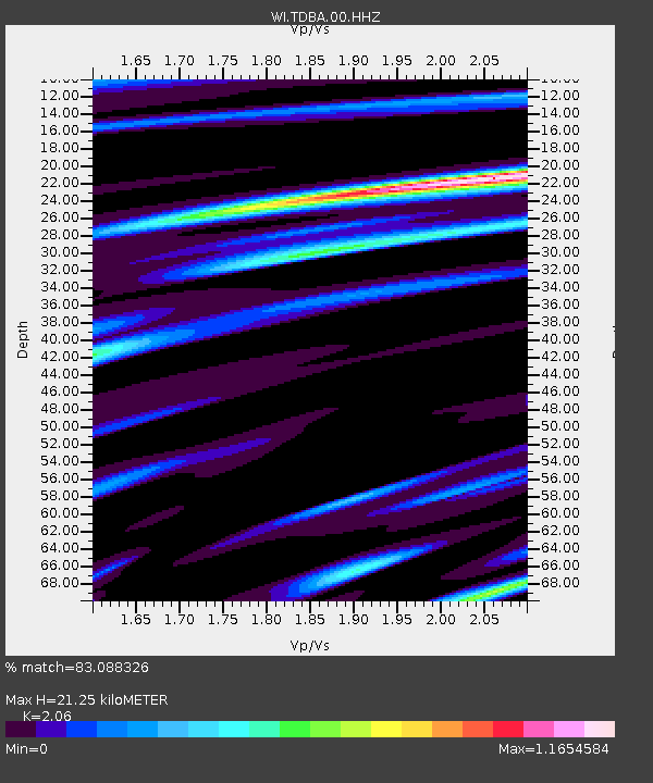
| Estimated Moho Depth: |
21.25 km |
| Estimated Crust Vp/Vs: |
2.06 |
| Assumed Crust Vp: |
5.88 km/s |
| Estimated Crust Vs: |
2.855 km/s |
| Estimated Crust Poisson's Ratio: |
0.35 |
|
| Radial Match: |
83.088326 % |
| Radial Bump: |
400 |
| Transverse Match: |
61.98833 % |
| Transverse Bump: |
400 |
| SOD ConfigId: |
1475611 |
| Insert Time: |
2016-05-13 01:43:29.398 +0000 |
| GWidth: |
2.5 |
| Max Bumps: |
400 |
| Tol: |
0.001 |
|

Signal To Noise
| Channel | StoN | STA | LTA |
| WI:TDBA:00:HHZ:20160429T01:40:53.990013Z | 8.449255 | 4.1606645E-6 | 4.9242976E-7 |
| WI:TDBA:00:HHN:20160429T01:40:53.990013Z | 1.008202 | 1.0452603E-6 | 1.0367569E-6 |
| WI:TDBA:00:HHE:20160429T01:40:53.990013Z | 3.575267 | 2.6339494E-6 | 7.36714E-7 |
| Arrivals |
| Ps | 4.0 SECOND |
| PpPs | 11 SECOND |
| PsPs/PpSs | 15 SECOND |


