You are here: Home > Network List > TA - USArray Transportable Network (new EarthScope stations) Stations List
> Station G21K Allakaket, AK, USA > Earthquake Result Viewer
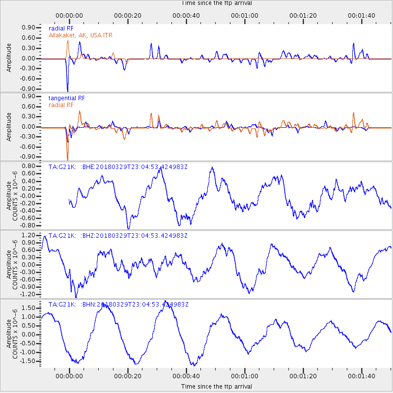
G21K Allakaket, AK, USA - Earthquake Result Viewer
*The percent match for this event was below the threshold and hence no stack was calculated.
| Earthquake location: |
Tajikistan |
| Earthquake latitude/longitude: |
38.7/70.0 |
| Earthquake time(UTC): |
2018/03/29 (088) 22:54:12 GMT |
| Earthquake Depth: |
3.6 km |
| Earthquake Magnitude: |
5.6 mb |
| Earthquake Catalog/Contributor: |
NEIC PDE/us |
|
| Network: |
TA USArray Transportable Network (new EarthScope stations) |
| Station: |
G21K Allakaket, AK, USA |
| Lat/Lon: |
66.52 N/153.51 W |
| Elevation: |
446 m |
|
| Distance: |
69.9 deg |
| Az: |
17.069 deg |
| Baz: |
325.056 deg |
| Ray Param: |
$rayparam |
*The percent match for this event was below the threshold and hence was not used in the summary stack. |
|
| Radial Match: |
84.34694 % |
| Radial Bump: |
276 |
| Transverse Match: |
77.4823 % |
| Transverse Bump: |
307 |
| SOD ConfigId: |
13570011 |
| Insert Time: |
2019-04-30 01:11:48.970 +0000 |
| GWidth: |
2.5 |
| Max Bumps: |
400 |
| Tol: |
0.001 |
|
Signal To Noise
| Channel | StoN | STA | LTA |
| TA:G21K: :BHZ:20180329T23:04:53.424983Z | 2.0008693 | 9.355928E-7 | 4.6759317E-7 |
| TA:G21K: :BHN:20180329T23:04:53.424983Z | 1.6481808 | 1.4964767E-6 | 9.0795663E-7 |
| TA:G21K: :BHE:20180329T23:04:53.424983Z | 1.3267038 | 4.8729754E-7 | 3.672994E-7 |
| Arrivals |
| Ps | |
| PpPs | |
| PsPs/PpSs | |


