You are here: Home > Network List > TA - USArray Transportable Network (new EarthScope stations) Stations List
> Station D25K Kavik River, AK, USA > Earthquake Result Viewer
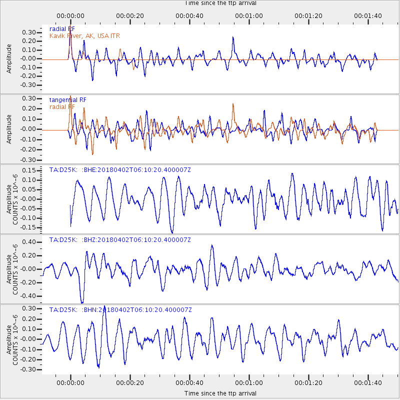
D25K Kavik River, AK, USA - Earthquake Result Viewer
*The percent match for this event was below the threshold and hence no stack was calculated.
| Earthquake location: |
South Of Fiji Islands |
| Earthquake latitude/longitude: |
-24.9/-176.6 |
| Earthquake time(UTC): |
2018/04/02 (092) 05:57:31 GMT |
| Earthquake Depth: |
84 km |
| Earthquake Magnitude: |
6.1 Mww |
| Earthquake Catalog/Contributor: |
NEIC PDE/us |
|
| Network: |
TA USArray Transportable Network (new EarthScope stations) |
| Station: |
D25K Kavik River, AK, USA |
| Lat/Lon: |
69.32 N/146.38 W |
| Elevation: |
770 m |
|
| Distance: |
96.5 deg |
| Az: |
10.369 deg |
| Baz: |
207.397 deg |
| Ray Param: |
$rayparam |
*The percent match for this event was below the threshold and hence was not used in the summary stack. |
|
| Radial Match: |
67.288666 % |
| Radial Bump: |
393 |
| Transverse Match: |
60.58241 % |
| Transverse Bump: |
400 |
| SOD ConfigId: |
13570011 |
| Insert Time: |
2019-04-30 01:19:30.527 +0000 |
| GWidth: |
2.5 |
| Max Bumps: |
400 |
| Tol: |
0.001 |
|
Signal To Noise
| Channel | StoN | STA | LTA |
| TA:D25K: :BHZ:20180402T06:10:20.400007Z | 2.5540342 | 2.2954175E-7 | 8.9874185E-8 |
| TA:D25K: :BHN:20180402T06:10:20.400007Z | 1.6291616 | 1.3624586E-7 | 8.362944E-8 |
| TA:D25K: :BHE:20180402T06:10:20.400007Z | 1.6844852 | 1.0644542E-7 | 6.319166E-8 |
| Arrivals |
| Ps | |
| PpPs | |
| PsPs/PpSs | |


