You are here: Home > Network List > TA - USArray Transportable Network (new EarthScope stations) Stations List
> Station J18K Innoko River, AK, USA > Earthquake Result Viewer
J18K Innoko River, AK, USA - Earthquake Result Viewer
| Earthquake location: |
South Of Fiji Islands |
| Earthquake latitude/longitude: |
-24.9/-176.6 |
| Earthquake time(UTC): |
2018/04/02 (092) 05:57:31 GMT |
| Earthquake Depth: |
84 km |
| Earthquake Magnitude: |
6.1 Mww |
| Earthquake Catalog/Contributor: |
NEIC PDE/us |
|
| Network: |
TA USArray Transportable Network (new EarthScope stations) |
| Station: |
J18K Innoko River, AK, USA |
| Lat/Lon: |
63.47 N/156.72 W |
| Elevation: |
506 m |
|
| Distance: |
89.5 deg |
| Az: |
8.79 deg |
| Baz: |
197.998 deg |
| Ray Param: |
0.041727815 |
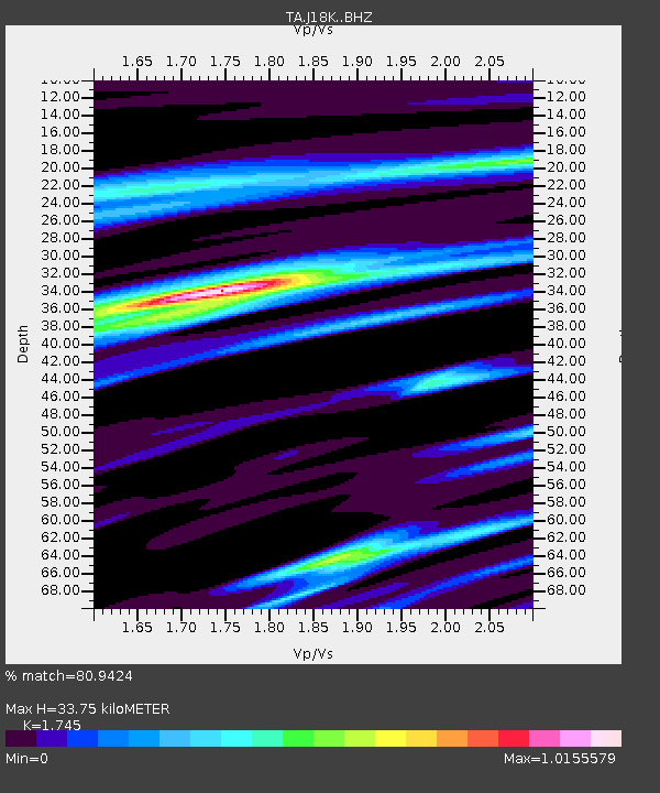
| Estimated Moho Depth: |
33.75 km |
| Estimated Crust Vp/Vs: |
1.75 |
| Assumed Crust Vp: |
6.182 km/s |
| Estimated Crust Vs: |
3.543 km/s |
| Estimated Crust Poisson's Ratio: |
0.26 |
|
| Radial Match: |
80.9424 % |
| Radial Bump: |
289 |
| Transverse Match: |
73.09665 % |
| Transverse Bump: |
346 |
| SOD ConfigId: |
13570011 |
| Insert Time: |
2019-04-30 01:20:12.413 +0000 |
| GWidth: |
2.5 |
| Max Bumps: |
400 |
| Tol: |
0.001 |
|

Signal To Noise
| Channel | StoN | STA | LTA |
| TA:J18K: :BHZ:20180402T06:09:48.299971Z | 10.881252 | 7.563746E-7 | 6.951173E-8 |
| TA:J18K: :BHN:20180402T06:09:48.299971Z | 3.1261256 | 2.5241567E-7 | 8.074393E-8 |
| TA:J18K: :BHE:20180402T06:09:48.299971Z | 1.9336675 | 1.7252867E-7 | 8.922355E-8 |
| Arrivals |
| Ps | 4.1 SECOND |
| PpPs | 15 SECOND |
| PsPs/PpSs | 19 SECOND |


