You are here: Home > Network List > TA - USArray Transportable Network (new EarthScope stations) Stations List
> Station L19K White Mountain, AK, USA > Earthquake Result Viewer
L19K White Mountain, AK, USA - Earthquake Result Viewer
| Earthquake location: |
South Of Fiji Islands |
| Earthquake latitude/longitude: |
-24.9/-176.6 |
| Earthquake time(UTC): |
2018/04/02 (092) 05:57:31 GMT |
| Earthquake Depth: |
84 km |
| Earthquake Magnitude: |
6.1 Mww |
| Earthquake Catalog/Contributor: |
NEIC PDE/us |
|
| Network: |
TA USArray Transportable Network (new EarthScope stations) |
| Station: |
L19K White Mountain, AK, USA |
| Lat/Lon: |
62.18 N/154.85 W |
| Elevation: |
650 m |
|
| Distance: |
88.5 deg |
| Az: |
10.015 deg |
| Baz: |
199.673 deg |
| Ray Param: |
0.042365078 |
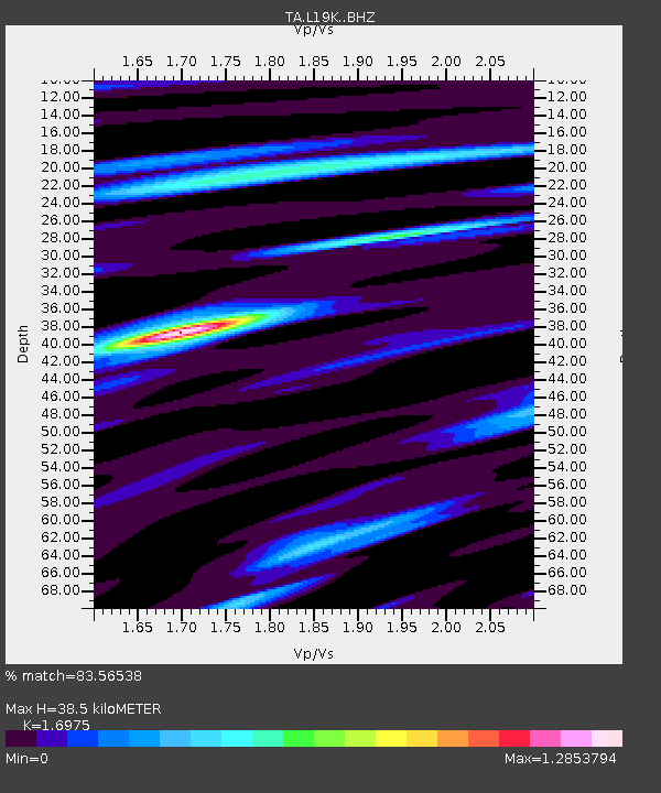
| Estimated Moho Depth: |
38.5 km |
| Estimated Crust Vp/Vs: |
1.70 |
| Assumed Crust Vp: |
6.438 km/s |
| Estimated Crust Vs: |
3.793 km/s |
| Estimated Crust Poisson's Ratio: |
0.23 |
|
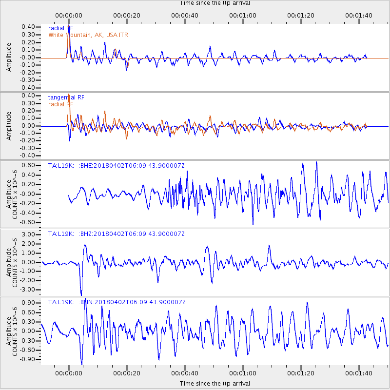
| Radial Match: |
83.56538 % |
| Radial Bump: |
374 |
| Transverse Match: |
75.42681 % |
| Transverse Bump: |
400 |
| SOD ConfigId: |
13570011 |
| Insert Time: |
2019-04-30 01:20:25.984 +0000 |
| GWidth: |
2.5 |
| Max Bumps: |
400 |
| Tol: |
0.001 |
|
Signal To Noise
| Channel | StoN | STA | LTA |
| TA:L19K: :BHZ:20180402T06:09:43.900007Z | 10.762078 | 1.1261933E-6 | 1.046446E-7 |
| TA:L19K: :BHN:20180402T06:09:43.900007Z | 2.1949959 | 3.5961216E-7 | 1.6383272E-7 |
| TA:L19K: :BHE:20180402T06:09:43.900007Z | 1.500428 | 1.1910338E-7 | 7.93796E-8 |
| Arrivals |
| Ps | 4.3 SECOND |
| PpPs | 16 SECOND |
| PsPs/PpSs | 20 SECOND |


