You are here: Home > Network List > TA - USArray Transportable Network (new EarthScope stations) Stations List
> Station M11K Mekoryuk, AK, USA > Earthquake Result Viewer
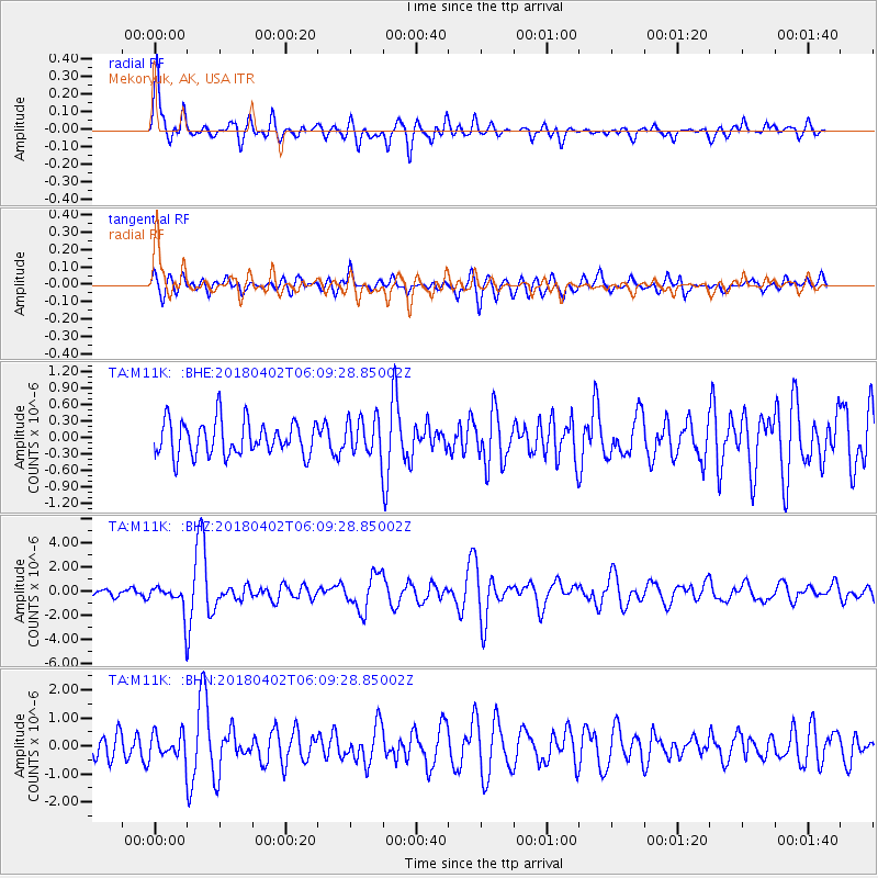
M11K Mekoryuk, AK, USA - Earthquake Result Viewer
*The percent match for this event was below the threshold and hence no stack was calculated.
| Earthquake location: |
South Of Fiji Islands |
| Earthquake latitude/longitude: |
-24.9/-176.6 |
| Earthquake time(UTC): |
2018/04/02 (092) 05:57:31 GMT |
| Earthquake Depth: |
84 km |
| Earthquake Magnitude: |
6.1 Mww |
| Earthquake Catalog/Contributor: |
NEIC PDE/us |
|
| Network: |
TA USArray Transportable Network (new EarthScope stations) |
| Station: |
M11K Mekoryuk, AK, USA |
| Lat/Lon: |
60.38 N/166.20 W |
| Elevation: |
3.0 m |
|
| Distance: |
85.4 deg |
| Az: |
5.163 deg |
| Baz: |
189.47 deg |
| Ray Param: |
$rayparam |
*The percent match for this event was below the threshold and hence was not used in the summary stack. |
|
| Radial Match: |
76.67411 % |
| Radial Bump: |
400 |
| Transverse Match: |
71.35023 % |
| Transverse Bump: |
400 |
| SOD ConfigId: |
13570011 |
| Insert Time: |
2019-04-30 01:20:30.123 +0000 |
| GWidth: |
2.5 |
| Max Bumps: |
400 |
| Tol: |
0.001 |
|
Signal To Noise
| Channel | StoN | STA | LTA |
| TA:M11K: :BHZ:20180402T06:09:28.85002Z | 3.1272972 | 1.1510174E-6 | 3.6805503E-7 |
| TA:M11K: :BHN:20180402T06:09:28.85002Z | 1.3084503 | 4.355902E-7 | 3.3290542E-7 |
| TA:M11K: :BHE:20180402T06:09:28.85002Z | 1.0674986 | 3.3082443E-7 | 3.099062E-7 |
| Arrivals |
| Ps | |
| PpPs | |
| PsPs/PpSs | |


