You are here: Home > Network List > TA - USArray Transportable Network (new EarthScope stations) Stations List
> Station M16K Timber Creek, AK, USA > Earthquake Result Viewer
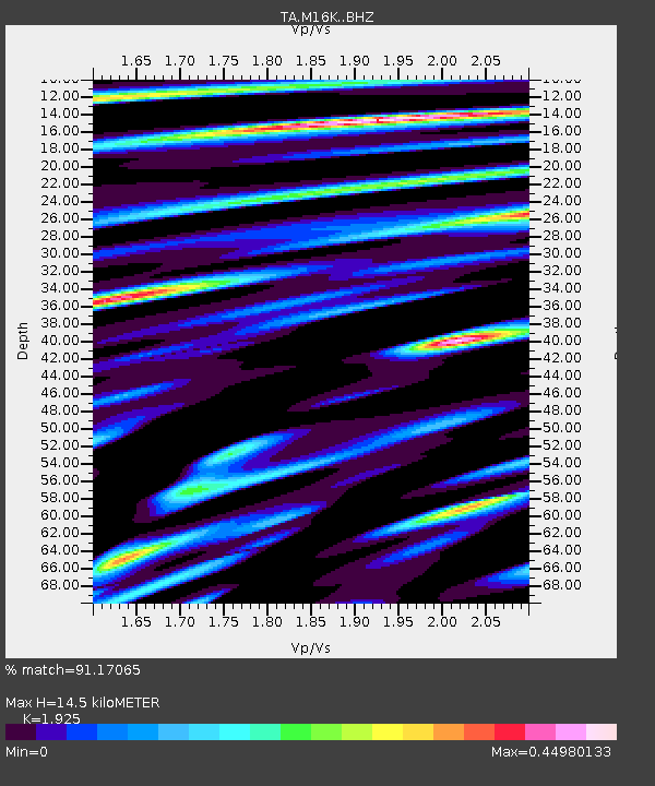
M16K Timber Creek, AK, USA - Earthquake Result Viewer
| Earthquake location: |
South Of Fiji Islands |
| Earthquake latitude/longitude: |
-24.9/-176.6 |
| Earthquake time(UTC): |
2018/04/02 (092) 05:57:31 GMT |
| Earthquake Depth: |
84 km |
| Earthquake Magnitude: |
6.1 Mww |
| Earthquake Catalog/Contributor: |
NEIC PDE/us |
|
| Network: |
TA USArray Transportable Network (new EarthScope stations) |
| Station: |
M16K Timber Creek, AK, USA |
| Lat/Lon: |
61.02 N/158.96 W |
| Elevation: |
394 m |
|
| Distance: |
86.8 deg |
| Az: |
8.502 deg |
| Baz: |
196.005 deg |
| Ray Param: |
0.043616094 |
| Estimated Moho Depth: |
14.5 km |
| Estimated Crust Vp/Vs: |
1.92 |
| Assumed Crust Vp: |
6.276 km/s |
| Estimated Crust Vs: |
3.26 km/s |
| Estimated Crust Poisson's Ratio: |
0.32 |
|
| Radial Match: |
91.17065 % |
| Radial Bump: |
261 |
| Transverse Match: |
90.20905 % |
| Transverse Bump: |
252 |
| SOD ConfigId: |
13570011 |
| Insert Time: |
2019-04-30 01:20:33.255 +0000 |
| GWidth: |
2.5 |
| Max Bumps: |
400 |
| Tol: |
0.001 |
|

Signal To Noise
| Channel | StoN | STA | LTA |
| TA:M16K: :BHZ:20180402T06:09:35.749983Z | 8.339206 | 8.737496E-7 | 1.0477613E-7 |
| TA:M16K: :BHN:20180402T06:09:35.749983Z | 1.7228706 | 2.2757081E-7 | 1.3208816E-7 |
| TA:M16K: :BHE:20180402T06:09:35.749983Z | 0.6890788 | 1.17106985E-7 | 1.6994716E-7 |
| Arrivals |
| Ps | 2.2 SECOND |
| PpPs | 6.6 SECOND |
| PsPs/PpSs | 8.8 SECOND |


