You are here: Home > Network List > TA - USArray Transportable Network (new EarthScope stations) Stations List
> Station M17K Holitna River, AK, USA > Earthquake Result Viewer
M17K Holitna River, AK, USA - Earthquake Result Viewer
| Earthquake location: |
South Of Fiji Islands |
| Earthquake latitude/longitude: |
-24.9/-176.6 |
| Earthquake time(UTC): |
2018/04/02 (092) 05:57:31 GMT |
| Earthquake Depth: |
84 km |
| Earthquake Magnitude: |
6.1 Mww |
| Earthquake Catalog/Contributor: |
NEIC PDE/us |
|
| Network: |
TA USArray Transportable Network (new EarthScope stations) |
| Station: |
M17K Holitna River, AK, USA |
| Lat/Lon: |
61.40 N/157.44 W |
| Elevation: |
387 m |
|
| Distance: |
87.4 deg |
| Az: |
9.099 deg |
| Baz: |
197.367 deg |
| Ray Param: |
0.043204125 |
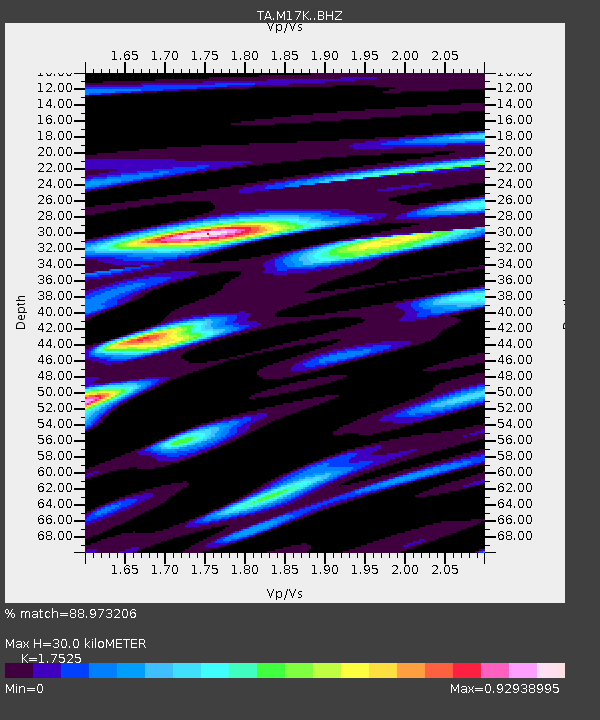
| Estimated Moho Depth: |
30.0 km |
| Estimated Crust Vp/Vs: |
1.75 |
| Assumed Crust Vp: |
6.155 km/s |
| Estimated Crust Vs: |
3.512 km/s |
| Estimated Crust Poisson's Ratio: |
0.26 |
|
| Radial Match: |
88.973206 % |
| Radial Bump: |
400 |
| Transverse Match: |
67.36277 % |
| Transverse Bump: |
400 |
| SOD ConfigId: |
13570011 |
| Insert Time: |
2019-04-30 01:20:34.775 +0000 |
| GWidth: |
2.5 |
| Max Bumps: |
400 |
| Tol: |
0.001 |
|

Signal To Noise
| Channel | StoN | STA | LTA |
| TA:M17K: :BHZ:20180402T06:09:38.525007Z | 5.800015 | 9.754551E-7 | 1.6818147E-7 |
| TA:M17K: :BHN:20180402T06:09:38.525007Z | 1.2830684 | 1.754948E-7 | 1.3677743E-7 |
| TA:M17K: :BHE:20180402T06:09:38.525007Z | 0.398019 | 1.2383367E-7 | 3.11125E-7 |
| Arrivals |
| Ps | 3.7 SECOND |
| PpPs | 13 SECOND |
| PsPs/PpSs | 17 SECOND |


