You are here: Home > Network List > TA - USArray Transportable Network (new EarthScope stations) Stations List
> Station K14A Jones Ranch, Declo, ID, USA > Earthquake Result Viewer
K14A Jones Ranch, Declo, ID, USA - Earthquake Result Viewer
| Earthquake location: |
Kuril Islands |
| Earthquake latitude/longitude: |
49.9/156.4 |
| Earthquake time(UTC): |
2008/08/04 (217) 04:42:14 GMT |
| Earthquake Depth: |
77 km |
| Earthquake Magnitude: |
5.6 MB, 5.8 MW, 5.7 MW |
| Earthquake Catalog/Contributor: |
WHDF/NEIC |
|
| Network: |
TA USArray Transportable Network (new EarthScope stations) |
| Station: |
K14A Jones Ranch, Declo, ID, USA |
| Lat/Lon: |
42.55 N/113.18 W |
| Elevation: |
1387 m |
|
| Distance: |
59.3 deg |
| Az: |
59.204 deg |
| Baz: |
311.202 deg |
| Ray Param: |
0.062038943 |
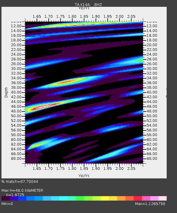
| Estimated Moho Depth: |
46.0 km |
| Estimated Crust Vp/Vs: |
1.67 |
| Assumed Crust Vp: |
6.279 km/s |
| Estimated Crust Vs: |
3.754 km/s |
| Estimated Crust Poisson's Ratio: |
0.22 |
|
| Radial Match: |
87.70044 % |
| Radial Bump: |
400 |
| Transverse Match: |
84.02674 % |
| Transverse Bump: |
400 |
| SOD ConfigId: |
2504 |
| Insert Time: |
2010-03-06 10:15:02.856 +0000 |
| GWidth: |
2.5 |
| Max Bumps: |
400 |
| Tol: |
0.001 |
|
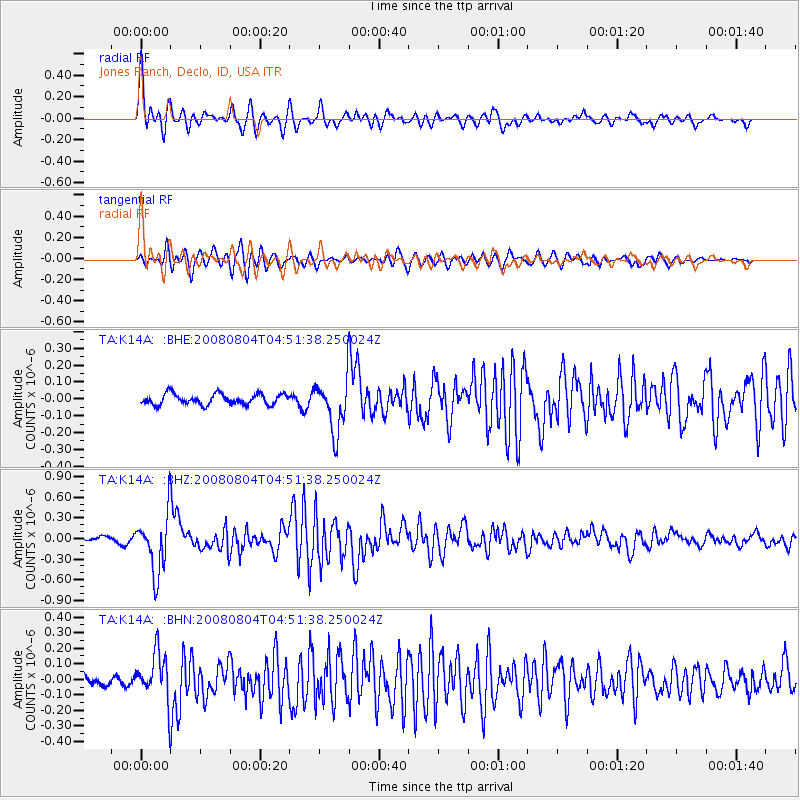
Signal To Noise
| Channel | StoN | STA | LTA |
| TA:K14A: :BHZ:20080804T04:51:38.250024Z | 10.888242 | 4.2381342E-7 | 3.8923954E-8 |
| TA:K14A: :BHN:20080804T04:51:38.250024Z | 4.7985477 | 1.5156195E-7 | 3.158496E-8 |
| TA:K14A: :BHE:20080804T04:51:38.250024Z | 5.023138 | 1.57369E-7 | 3.132882E-8 |
| Arrivals |
| Ps | 5.2 SECOND |
| PpPs | 19 SECOND |
| PsPs/PpSs | 24 SECOND |


